E-Paper



Number Theory: Surplus but skewed rains mark southwest monsoon
India received 575mm rain up to August 8 this monsoon. This is 12.1% more than the average for the period during 1971-2020, considered the Long Period Average
Updated on: Aug 10, 2024, 11:16:07 IST

 Prefer HTon Google
Share via


Copy link

More than half of the southwest monsoon season – which runs from June to September – is over. How has the rainfall been so far this monsoon? The gridded database of the India Meteorological Department (IMD) shows that cumulative rain now has a big surplus at the countrywide level. However, the spatial and temporal distribution of rain is so skewed that this country-level trend has little meaning.

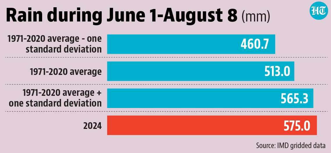
 The rain during June 1-August 8 is the 12th highest since 1901India received 575mm rain up to August 8 this monsoon. This is 12.1% more than the average for the period during 1971-2020, considered the Long Period Average (LPA) of rain currently by IMD for testing the adequacy, or lack of it, of the annual rainfall. Is it unusual? Yes, because the rain this year is the 12th highest since 1901 for the June 1-August 8 period. There is another way to look at this. During the 1971-2020 period, the standard deviation of rain’s departure from the average was 10.2% for the June 1-August 8 period. Since the departure this year is around two percentage points higher, it is more than what was usual in the 1971-2020 period.
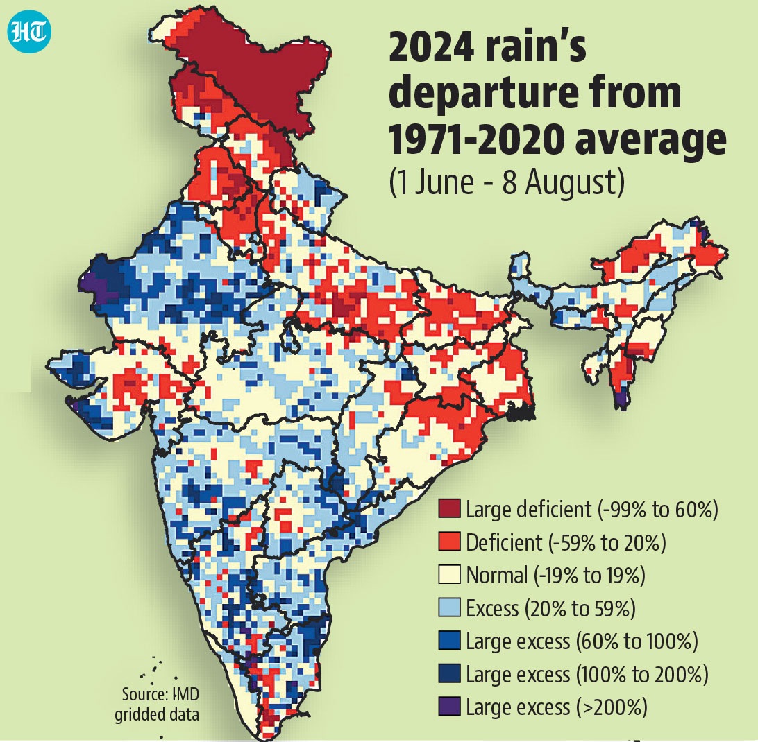
- But a quarter of the country’s area still has bigger deficits than usualWhile 41% of the country has received a surplus of at least 20% (classified as different degrees of “excess” by IMD for local rain), a quarter of the country has a deficit of 20% or more (classified as different degrees of “deficient”). Only 34% of the country has a surplus or deficit of under 20%, which is classified as “normal”. Deficient area covers large parts of states such as Punjab, Haryana, Uttar Pradesh, Bihar, Jharkhand, West Bengal, Jharkhand and Odisha, as well as the UTs of Jammu & Kashmir and Ladakh. Areas with excess rain can be found in flood-affected states, but it is not necessary that all places with a big surplus were flooded. One reason for this is that floods are also a function of other factors such as built-up area and drainage. Another reason is that even a big surplus may not mean a dangerous intensity in regions where June-September is not the main rainy season, such as Tamil Nadu.
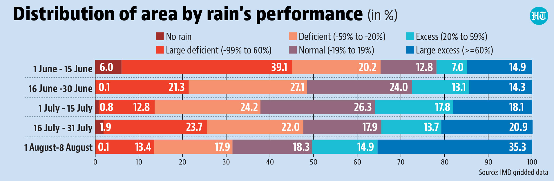
- There was wide variation in wet and dry areas in different parts of the seasonThe regional skew in cumulative rain can still hide rain’s role in disasters. For example, despite the floods and rain-triggered landslides, 66% of Kerala is in the “normal” category, the highest proportion among all big states. This is because most of the state is deficient this month, and was normal or deficient through most of the season even earlier. However, this was not the case in the second half of July, when the disasters took place. Even summary numbers show that the regional skew has been different in different parts of the season. For example, 65% of the country was deficient in the first half of June, compared to only 32% in the August. Similarly, only 18% of the country received has normal rain in August so far compared to 26% in the first 15 days of July.
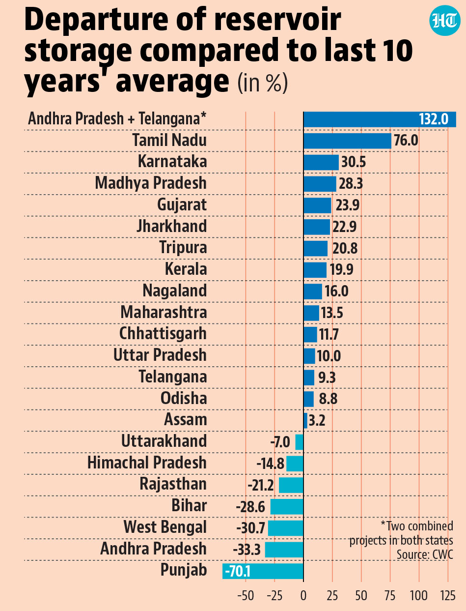
- The patchy rain has created a regional skew in reservoir storageThe importance of temporal distribution in rainfall does not make cumulative rainfall completely meaningless. It has implications for the stock of water that is stored during the season. For example, states with big deficits in rain -- such as Punjab, Bihar, and West Bengal -- also show a deficit in the storage level of the reservoirs monitored by the Central Water Commission (CWC). On the other hand, peninsular states have a surplus in storage because it is unusually rainy there.
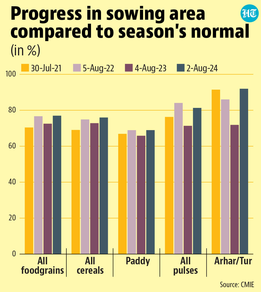
- But paddy and pigeon pea sowing has progressed better than in recent yearsWhile the monsoon’s regional and temporal skew has led to disasters, it has not adversely affected the two main crops of the season: paddy and arhar (pigeon pea). The sowing of both crops is progressing at a rate better than in recent years. However, it is possible that rain’s regional skew affects output of these crops (or of vegetables) in particular parts of the country. Moreover, IMD’s forecast for the second half of the season suggests that some regions may receive surplus rain in September. This may not be good if paddy’s cycle is ending at the time, when the crop requires rains to ease up.