
 E-Paper



Wet spell across India as rains advance, ‘orange’ alert in hills
The monsoon will have traversed all of the country over the next two days, IMD said in its bulletin.

 Prefer HTon Google


Rains and storms continued to lash several parts of north, northwest and central India on Tuesday, as the southwest monsoon made further strides into the rest of the country, said India Meteorological Department (IMD) officials, with overnight showers also helping keep Delhi cooler than usual.
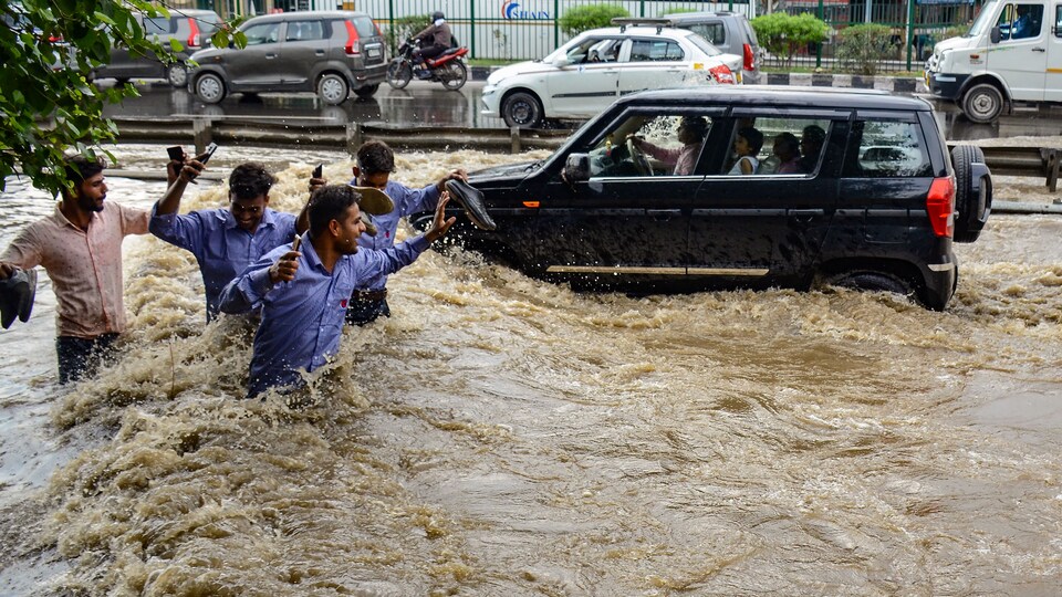
The national weather office said the southwest monsoon has now blanketed most of the country, with only the northern parts of Rajasthan, and small patches of Haryana and Punjab being the regions beyond the rainy season’s footprint.
Read | Rain triggers landslides in Himachal, hundreds stranded as Mandi-Kullu highway blocked
The monsoon will have traversed all of the country over the next two days, IMD said in its bulletin.
“The southwest monsoon has further advanced into most parts of north Arabian Sea, the remaining parts of Gujarat and some more parts of Rajasthan,” it said.
“Conditions are favourable for the further advancement of the southwest monsoon into some more parts of Rajasthan and the remaining parts of Haryana and Punjab during the next two days,” said IMD.
Meanwhile, the weather office issued orange alerts for Uttarakhand, as well as parts of Madhya Pradesh, Rajasthan and Maharashtra.
Also read | IMD predicts heavy rainfall for next 2 days in Mumbai, central Maharashtra: Latest Updates
An orange warning implies that disaster management authorities should be prepared to avert any rain related disasters or flooding.
Himachal Pradesh, Uttarakhand, Delhi, Haryana, Punjab, Gujarat, Madhya Pradesh, Odisha, West Bengal and Jharkhand all received sharp spells of rain on Tuesday, said data from the weather office.
In Delhi, showers early on Tuesday helped push the minimum temperature to 24.5°C, (four below normal) and the maximum to 34.8°C (two below normal), even as authorities worked to shore up infrastructure and prepare for more rains over the next few days.
Read here: Unusual pattern sheds light on how monsoon line takes shape
Meanwhile, at least six people were killed in Himachal Pradesh between Monday and Tuesday, said authorities in the state, which has borne the brunt of a monsoon that has barrelled through the country with renewed vigour over the past few days, after cyclone Biparjoy hit the brakes on the season’s progress two weeks ago.
IMD warned that the state is set to receive more rain for the rest of the week, with strong showers likely in some parts.
“There is a possibility of rain for the next five days. Heavy rain alert continues at some places of the state,” said Sandeep Kumar Sharma, IMD scientist, Shimla.
The state government advised tourists and residents to avoid unnecessary travel and not to venture near rivers and landslide-prone areas.
“When travelling in hilly areas, particularly in upper Shimla, Kinnaur, Mandi, Kullu, Lahaul and Spiti, and Chamba districts, people must gather comprehensive information about the weather and road conditions and follow the advisory provided by the local administration,” the Himachal Pradesh traffic police said.
The advisory came two days after authorities began reopening the popular Chandigarh-Manali, which was shut as landslides ripped through the streets and swept away vehicles.
To be sure, Himachal Pradesh received just 6mm of rain on Tuesday, slightly more than the 4.5mm it receives on an average.
This year’s monsoon has undergone an unusual surge, having lagged for most of June by bringing rains only to the southern peninsula before sweeping almost the entire country within a matter of days last weekend. It hit Mumbai and Delhi on the same day, arriving close to a fortnight late in the financial capital and a day in advance in the national capital — the first time this happened in 62 years.
Showers also lashed Uttarakhand, with Rudraprayag district receiving 21.4mm rainfall in 24 hours. There have been consistent concerns among residents and authorities in Uttarakhand, after cracks emerged in parts of the landslide- and subsidence-hit state.
Uttarakhand chief minister Pushkar Singh Dhami on Tuesday said the National Disaster Relief Force and Indo-Tibetan Border Police Force have been instructed to remain alert in the event of natural disasters.
The south-west monsoon also covered all of Gujarat on Tuesday, with many areas likely to receive heavy to very heavy rainfall over the next five days. “The southwest monsoon has further advanced into most parts of the north Arabian sea, remaining parts of Gujarat and thus covering the entire Gujarat state today, June 27,” IMD said.
Weather authorities also issued a “red warning” for south Gujarat’s Navsari and Valsad districts. A red category warning implies that disaster management authorities should take action to prevent any rain-related or flooding disaster.
Several states will likely see heavy rain on Tuesday, the Met said in its bulletin.
“Heavy to very heavy rainfall is likely at isolated places over sub-Himalayan West Bengal, Sikkim, Uttarakhand, Madhya Pradesh, Konkan & Goa, Madhya Maharashtra,” said IMD.
Heavy rainfall is likely at isolated places over Himachal Pradesh, West Uttar Pradesh, Rajasthan, Saurashtra & Kutch, Bihar, Odisha, Gangetic West Bengal, Vidarbha, Arunachal Pradesh, Assam, Meghalaya, Nagaland, Manipur, Mizoram and Tripura, it added.
Meanwhile, Mumbai received 104 mm of rain on Tuesday, as strong showers continued to pound Maharashtra’s capital. Rains in the state will increase gradually over the next few days, said officials.
“The intensity of rain will gradually increase over parts of Maharashtra during the next four or five days,” said the local weather office, adding that severe weather is likely over the next five days.


