E-Paper


Tropical Storm Chantal: These North Carolina counties face severe flash flood threats
Chantal, the first tropical storm of the hurricane season to make landfall in the US brings risk of torrential rain to North Carolina and Mid-Atlantic states.

 Prefer HTon Google


Remnants of tropical storm Chantal, the first storm of the 2025 Atlantic hurricane season to make landfall in the US, have caused scattered showers and thunderstorms in parts of inland North Carolina. The storm made an early landfall in South Carolina, near Myrtle Beach, on Sunday morning. Although the storm weakened into a tropical depression on Sunday afternoon, it continues to pose a risk of flash flooding in the state, ABC reported.
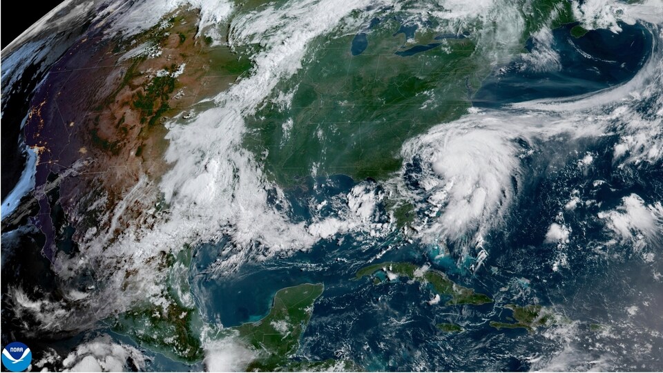
The storm’s outer bands, according to a report in The Washington Post, brought gusty winds up to 50mph and heavy downpour to parts of South Carolina during landfall. As the system moved inland, central and eastern North Carolina began to experience showers.
Flood watches for central and eastern North Carolina
The Washington Post reported that North Carolina could see two to four inches of rainfall, with some areas, particularly in the Piedmont and Sandhills, receiving over six inches of rain.
An ABC news report stated that the torrential rain has prompted flood watches in more than two dozen counties, including Fayetteville, Raleigh-Durham, and Greensboro. These alerts will reportedly remain in effect until Monday, with flash flooding identified as the primary concern.
Also read: Camp Mystic flooding: How many girls are still missing after the deadly Texas floods?
Storm risk continues along the East Coast
Chantal’s circulation, according to the Washington Post report, is also likely to continue to trigger severe thunderstorms across eastern North Carolina. The National Weather Service has warned of the possibility of isolated tornadoes and strong gusts of wind, as well as dangerous surf and rip currents along coastal areas from northeastern Florida up through Virginia Beach.
As Chantal’s moisture shifts northward into the Mid-Atlantic on Monday, areas like Washington, DC, southern Maryland, eastern Virginia, and Delaware may see intense rainfall and further flash flood risk. The heaviest bands are expected to move just south of DC.
By early Tuesday, Chantal’s remnants will pass offshore near Cape Cod, as per the Washington Post; however, lingering tropical moisture, with an approaching front, is expected to keep stormy weather in the forecast for parts of the Appalachians, Mid-Atlantic, and Northeast through midweek.
The ABC News report added that the weather across North Carolina will remain unsettled. Spotty showers are likely on Monday along and east of I-95, followed by hot and humid conditions on Tuesday with heat index values surpassing 100°F.
FAQs
Where did Tropical Storm Chantal make landfall?
Chantal made landfall near Myrtle Beach, South Carolina, early Sunday morning.
Is Chantal still a tropical storm?
No, as of Sunday afternoon, Chantal weakened to a tropical depression and is expected to dissipate later today.
Which areas are under flood watches?
Flood watches are in effect for parts of inland and central North Carolina, including Raleigh-Durham, Greensboro, and Fayetteville.
What should residents expect this week?
Residents should prepare for additional heavy rainfall and stormy conditions, especially through Wednesday. Flash flooding and severe storms remain possible.