
 E-Paper



Experts blame unplanned growth, BBMP for water mayhem
In several localities in the city, tractors were used to ferry residents from their homes to safer places and JCBs were used to give food to people stranded in multi-storey housing complexes.

 Prefer HTon Google


As Bengaluru city received 131.6 mm rainfall in a 24-hour-period ending Monday morning, experts pointed out that it showed that the cyber capital of India was ill-prepared to deal with extreme rainfall events on account of poor planning or lack of it.
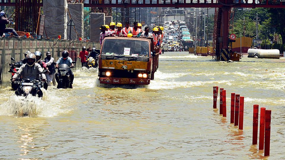
Picture of Bengaluru city on Monday presented water mayhem with boats being used to rescue stranded residents in the Mahadevapura and Bommanahalli zones of the city which are among the worst hit due to heavy downpour.
In several localities in the city, tractors were used to ferry residents from their homes to safer places and JCBs were used to give food to people stranded in multi-storey housing complexes.
People could be seen wading through almost waist-high depth of rain water in several localities, including the technology corridors between Silk Board and KR Puram as well as Manyata technology park.
“It’s so striking that it is one part of the town (city) which is now getting affected. It’s not the north or the west but that part that is getting affected,” Vishwanath S, an expert on rain water harvesting, said, while referring to the 110 new villages around the older periphery of Bengaluru. The said villages were made part of the city when the Bengaluru Mahanagara Palike became the Bruhat Bengaluru Mahanagara Palike (BBMP), expanding its boundaries by nearly 500 square km from 300 square km to almost 800 square km in 2007.
“The new infrastructure, the roads themselves are becoming the problem. They are acting as dams and preventing it (water). There is no respect for Rajakaluves (natural water flow systems),” he said.
According to the Land Use Land Cover (LULC) Dynamics paper by the Indian Institute of Science-Bengaluru, the city shows a 1005% increase in urban built up area between 1973-2016.
“Unplanned rapid urbanisation during post 2000’s (concentrated developmental activities due to IT parks and SEZ’s development in the city) has led to drastic and unrealistic land use changes (Ramachandra et al 2012). Urban land use shows that it is reaching saturation with respect to lateral development, whereas the scope of built up area development remains in vertical growth, but this will have telling influences on the city infrastructure (road, drinking water and sanitation facilities),” according to the report ‘Water Situation in Bengaluru’ by TV Ramachandra, Vinay S, Durga Madhab Mahapatra, Sincy Varghese and Bharath H Aithal.
They further show that vegetation in key catchment areas have declined by 88% and water bodies have declined by 79%.
“Land use prediction using Agent Based Model showed that built up area would increase to 93.3% by 2020, almost on the verge of saturation. Number of lakes in Bangalore has reduced by 790% from 1973 to 2016,” the report read.
“What Bengaluru saw today or in the past one week would be true with all cities in India as they don’t have infrastructure to cope with rising population load and upcoming new residential areas with poor infrastructure,” said Raj Bhagat, senior manager, GeoAnalytics at WRI India.
“I haven’t seen any major Indian city for which I could confidently say that the reason why there is flood related issues in X city is because of an unpredictable or climate change related rain event for which city was not ready. Right now, our cities are not ready for normal rain itself,” he said.
He added that this could be the case in any city which talks about such issues when it rains and then continue the same practices which created this problems in the first place.
However, the Bruhat Bengaluru Mahanagara Palike blamed the woes of the residents on excessive rainfall.
“If we look at rainfall data from 1971, it is the second highest rainfall in September after 1998. But this is one of the wettest monsoons in the history of Bengaluru,” Tushar Girinath, the BBMP chief commissioner said.
He added that normal rainfall between 1-5 September is around 25mm and there are localities which have received between 150-300 mm rainfall during the same period.
Between 1-5 September, Bommanahalli has seen 219% more rainfall as it recorded 80mm as against the normal of 21mm. Similarly, the other most impacted zone or locality is Mahadevapura, which recorded 104 mm rainfall in this period as against the normal of 27mm. There are at least eight localities that have received over 200% more rains this September, Girinath said, stating that this was the “context” with which the flooding in Benglauru must be viewed.
The BBMP officials conveniently sidestepped the problems exacerbated by the lack of planning, encroachment of valleys and lakes, poor drainage systems and unregulated expansion that has brought the city and its over 12 million residents to its knees once again.


