
 E-Paper



Maharashtra floods: State government ignored panels’ recommendations, say experts
Experts slam govt for its lack of willpower to take the steps recommended by committees formed to avert calamities


While experts attribute the flooding in Raigad, Ratnagiri, Kolhapur and Sangli broadly to climate change, reduction in tree cover and human intervention in the ecosystem, they have slammed the government for its lack of willpower to take the steps recommended by experts to avert such calamities.
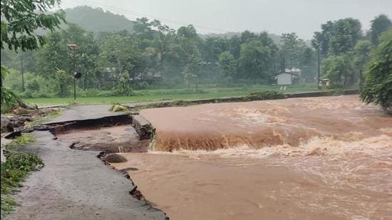
The downpour in Konkan and Western Maharashtra for three-four days since July 22 wreaked havoc in nine districts. It resulted in the loss of 213 lives, several are still missing and saw evacuation of more than 450,000 to safer places. Preliminary estimates by the state suggest the losses are expected to mount to more than ₹5,000 crore. This is second such flooding in Western Maharashtra in three years. The severity of the flooding could be indicated with the water level in Panchganga river, which was flowing at 55ft, much above its danger mark of 43ft.
The Madhav Gadgil committee on Western Ghats ecology and Vadnere committee appointed after the 2019 floods to recommend measures to avoid floods have submitted their comprehensive reports to the governments. Gurudas Nulkar, ecologist and trustee, Ecological Society, said, “Sahyadri range is the source region of rivers and the rain gets divided into Konkan and Deccan Plateau equally. Concentration of the rain run-off in the floodplain and cloudburst led to the flooding. Urbanisation has resulted in change in the natural landscape which takes the shape of saucer and the use of cement, tar, paver blocks result in hardscaping of the structures. This obstructs the percolation of the water,” he said.
“Similarly, the construction in river banks and floodplains lead to constricting of river channels. Owing to this, the rivers cannot hold the volume of water they were designed to hold naturally. Destruction to the riparian zones, which give stability to river banks, damage the first and second order streams due to construction and lead to disturbance of ecosystem. Secondly, the city drainage system is falling short for the flood waters. The pattern of the monsoon has changed. We get the season’s rainfall in just four days as cloudburst has become common phenomenon due to the climate change,” he said.
The Maharashtra government had appointed an expert committee of 10 members, headed by retired head of irrigation department Nandkumar Vadnere, in August 2019 immediately after the flooding in July-August that year to study the reasons and propose technical measures. Besides the demarcation of restricted zones by marking flood lines and identifying the flood plains, the committee had recommended removal and rehabilitation of encroachments. It recommended advanced weather forecasting systems, real time decision support (RTDS) systems, restoration of natural waterways and their desilting, strengthening of river meanders, construction of more flood dams, temporary flood storage tanks. The committee had also recommended strict implementation of the guidelines on the management of floods and urban flooding issued by National Disaster Management Authority in 2008 and 2010. The committee had recommended forming Flood Zoning Authority for two districts. It also recommended amendment in clause 16 of the Maharashtra Irrigation Act for demarcation of floodplain zones.
“The removal of encroachments is directly linked to political vote banks and hence nobody dares to touch them,” Nulkar said.
Madhav Gadgil, who headed the state appointed Western Ghat Ecology Expert Panel in 2010-11, said, “We had said that haphazard planning of highways by cutting mountains slopes, unchecked construction and mining activities should not be done. The recommendations were not followed by the government.”
Pradeep Purandare, retired professor from WALMI, irrigation expert and member of Vadnere committee, said, “The accurate balance between water stock in reservoirs and discharge of water is key.”
Shailaja Deshpande, ecologist and founder-director of Living River Foundation, Pune, said, “The committees have recommended their conservation to protect the ecosystem. The subsequent Kasturangan committee report which diluted Gadgil committee report by 50%, too, has been overlooked by authorities. There is no objection to the development, but there should have been watershed approach to it. The construction should be done by taking the particular landscape into consideration and respecting the ecosystem there.”
Deshpande said, “Areas like Chiplun, Mahad city will require specific measures for managing floods. In cities like Kolhapur, Sangli and confluence regions, floods will get retained over longer period due to morphological features of the landscape.”
Opposition leader and former CM Devendra Fadnavis said, “The state, by accepting the Vadnere committee report, should constitute a separate department for implementation of the recommendations. The state should implement the World Bank approved 2019-project for the diversion of the flood water to drought-prone areas through diversion canals.”
Deshpande also suggested dedicated guidelines for infrastructural developments in the districts which frequently witness the flooding.
Natural green belts along flood plains will act like buffers to manage and reduce intensity of floods.
Vijaykumar Gautam, officer on special duty , water resources department, said, “We have started holistic approach towards these problem by chalking out short-, mid- and long-term measures. For rapid alerts and forecast, 7 of the 26 Real Time Decision Support systems on rivers in Konkan will be installed in next three months. Similarly, there would be comprehensive plan for water management. Construction within the blue and red lines is the major problem.”
Gautam said completion of incomplete dams on Kalu, Shai in MMR and Kaal in Konkan is the need of the hour. “Had the dam on Kaal been completed within time, the water level in Vashisthi would not have increased more than 4ft, which had swelled to 11ft this time. Koyana absorbed 3.5 lakh cusecs of water, by releasing just 50,000 cusecs of water and played a great role of flood mitigation,” he said.
Vijay Nahata, member of State Environment Impact Assessment Committee, said, “There are financial constraints before the state while implementing the recommendations given by any committee. The government has started taking corrective steps in response.”

Stay updated with all the Breaking News and Latest News from Mumbai. Click here for comprehensive coverage of top Cities including Bengaluru, Delhi, Hyderabad, and more across India along with Stay informed on the latest happenings in World News.


