
 E-Paper



Mapped out: India, Mumbai over 350 years
Thirty two maps from the collection of the Asiatic Society of Mumbai will be on display for a month at the Asiatic Library’s Durbar hall


Mumbai: In his 1852 ‘Report on the Sanitary State and Sanitary Requirements of Bombay’, British engineer Henry Conybeare, who designed the city’s first water supply scheme from Vihar lake, rued the absence of “unity and system” in the “native” parts of the city and the near absence of drains and sewers. “Our town, with half a million inhabitants, is not divided (as for half a dozen municipal and sanitary purposes it ought to be) into any generally recognized districts and sub-divisions,” he wrote in the report, and attributed the higher mortality in these parts to the unsanitary conditions.
Conybeare, who was the superintendent of repairs for Bombay at the time, also went on to map the colonial city — ‘Map of the Native Town of Bombay’ showed the bunds and water tanks that supplied the areas stretching from Market (behind the Fort walls) to Kamathipura (spelt “Coomatteepoora”); and the ‘Map of the Fort of Bombay’ showcased the well-planned streets lined with houses of the “educated and influential classes”.
Both these maps, completed in 1855, were recently restored and form part of an exhibition that opened to the public on Saturday. Thirty two maps from the collection of the Asiatic Society of Mumbai will be on display for a month at the Asiatic Library’s Durbar hall. This includes one from 1652 made by Nicolas Sanson D’abbeville, the French royal cartographer, who mapped the Mughal empire, a map from the Great Trignometrical Survey (which was started in 1802 and conducted till the 1870s) showing the Chamba Valley, as well as a 7.5-ft long map on the Punjab and Sind province dating back to 1867. There are six that show Mumbai, including a 1710 pictorial view of the English Fort of Bombay as well as an 1896 map that detailed the various wards of the city and its hospitals during the plague outbreak.
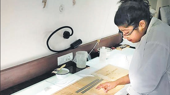
The maps were restored by independent paper and book conservator Amalina Dave and with funds organised by the Rotary Club of Mumbai.
“We have a very large collection of maps, it’s over a thousand. We had to be very selective for this exhibition. It gives you an idea of how cartographers, who did not have the sort of instrumentation available that current ones do, how they prepared these maps on the basis of what travellers told them and what they could discover about the country and its coastline. They are like works of art,” said Vispi Balaporia, the president of the Asiatic Society of Mumbai.
The changing idea of India
For Deepti Anand and Sanghamitra Chatterjee, co-founders of heritage management company Past Perfect and curators of the exhibition, the research threw up many frames of reference, and they wanted to go beyond the obvious one: map-making as a colonial tool. Anand and Chatterjee were more interested in what the cartographer sought to depict (and leave out) in the map, as well as in Dave’s journey as a conservator.
“We just knew this was the story we had to tell,” said Anand. Accordingly, each exhibit has a curator’s note, as well as a card titled ‘The ‘conservation’ conversation’, where Dave’s techniques and discoveries that were unique to the exhibit, are detailed.
“The exhibition shows how map-making as an exercise itself changed,” said Chatterjee, giving the example of Sanson’s 1652 map of the Mughal empire. “I call that map ‘brain-shaped India’,” said Anand, describing accurately the shape that the 17th century French cartographer accorded to the Indian emperor’s boundaries. “Though these were geographically inaccurate, these were referred to as accurate and were considered a benchmark in the travelogues of that time,” Anand said. What’s more, Sanson’s mission to map the lay of the land was because the French emperor wished to understand the trading outpost that other European countries like the Portuguese and the Dutch had already reached.
It’s in James Rennel’s ‘Map of Hindoostan’ (dated 1788) that we begin to see India as we recognise it today, emerge. The rivers, plateaus, villages are all visible in intricate detail: Rennel, who served as the surveyor general of Bengal for the East India Company, in fact, produced some of the most accurate maps of the subcontinent.
“As you move into the 19th century, the details change. The maps from the Great Trignometrical Survey show a higher level of accuracy, as a scientific approach that was more modern began to be employed in making of the maps,” Chatterjee said.
“Through these 32 maps, the idea of India as a landmass emerges. Some of the cartographers in the 17th and 18thcenturies produced maps for Europeans to vicariously experience the Orient, which was a relatively unfamiliar territory. By the 19th century, maps began to serve the purpose of colonial documentation and study,” Anand added.
The process of restoration
Dave’s association with the Asiatic Library started in 2017, when she proposed a pilot project of restoration of a smaller scale: new materials, new techniques, and a process to repair books without taking them apart.
A few years later, the Rotary Club of Mumbai was keen to start a cartographic restoration project. Dave made a project outline in 2019. However, with the pandemic-induced lockdowns, goalposts and deadlines shifted. New equipment also got added to the Asiatic Library’s existing restoration laboratory, including a low pressure table to aid in the cleaning and flattening of paper, with a humidification chamber to relax the fibres of brittle, creased or folded paper.
The weather played an important role in Dave’s decision on how to tackle the restoration. A high humidity environment like Mumbai, particularly during the monsoon, affected even the minutest of choices — like the sort adhesive used — that Dave made. “The thing we don’t realise is that there is no single recipe that will work in every context. It’s very much about figuring out the environment in this building and in this city, and then finding a solution that works.”
She took the example of Conybeare’s ‘Fort of Bombay’ map. “When I received the map for treatment, it was covered on both sides with Japanese tissue, and there were actually two things that happened. The tissue was protecting it from falling apart, and the pieces from dissociating. However, the tissue was also obscuring some of the damage. For example, you could not see that the map was in four pieces, nor could you see that there were several fragments of the map. In the restoration process, I had to put these fragments together and reattach them to the map.”
Describing the process of restoration, Dave said, “Since the map was so fragile, I didn’t want to expose it to water. So I did a dry-cleaning method, or surface cleaning, which involved rubbing a vulcanised rubber sponge over the surface of the map, which picks up the dirt and it can also brush off whatever it picks up. After that, I did a non-aqueous deacidification, which also didn’t involve water. All adhesives used on the map were alcohol-based. This helped mitigate the negative effects of water on the map, like crinkling or creasing.”
Dave also ensured that most of the treatment on the map — using cotton crinoline and Japanese paper, and alcohol-based adhesives — was done on the back of the map and not on its front, so that the elaborate details were not obscured. On the front of the map, Dave glued strips of tissue on the cracks to make sure that the alignment of the map didn’t shift. After mending the back, she removed these strips (“it’s quite easy; you just have to reactivate the glue and peel them off”). The last step was to put all the tiny pieces of paper that had fallen off, back in place on the map.
“The very last step is to find out where each of these pieces belong, and then press them down to ensure that they are properly incorporated into the map. It’s very risky because these small pieces are the easiest to lose.”
The philosophy of conservation
Unlike an oil painting where restoration involves renovation or repair to make the work like its original, Dave’s approach to these maps was decidedly different. In many, the paper was extremely fragile and brittle, so the strategies differed. “If I am to be completely abstract, the object would tell me [how to work on it]. I couldn’t go in with 100% certainty on what I was going to do,” Dave said. Yet, there were some tenets she stuck to.
The first, said Dave, is the Hippocratic oath: you do no harm.
The second is the principle of reversibility. “Everything I do to a map must be reversible. Thirty years from now… a conservator should be able to undo the work I’ve done. Years down the line, if a conservator with new techniques wants to redo a map, no damage will have come to it from what I have done.”
Third, conservation must be conservative. “Interventions when you are taking remedial steps for an object need to be as dialled back as possible, because the most important thing is the object. You want to see it the way it was intended. I approach it as let me see what I can do to preserve that intention. It’s a matter of balancing the intention of the original object with what is possible, practical and what will ensure longevity.”
Stay updated with all the Breaking News and Latest News from Mumbai. Click here for comprehensive coverage of top Cities including Bengaluru, Delhi, Hyderabad, and more across India along with Stay informed on the latest happenings in World News.


