
 E-Paper



A cooler than normal start to winter 2025-26 | Number Theory
.
Published on: Dec 26, 2025, 09:03:40 IST

 Prefer HTon Google
Share via


Copy link

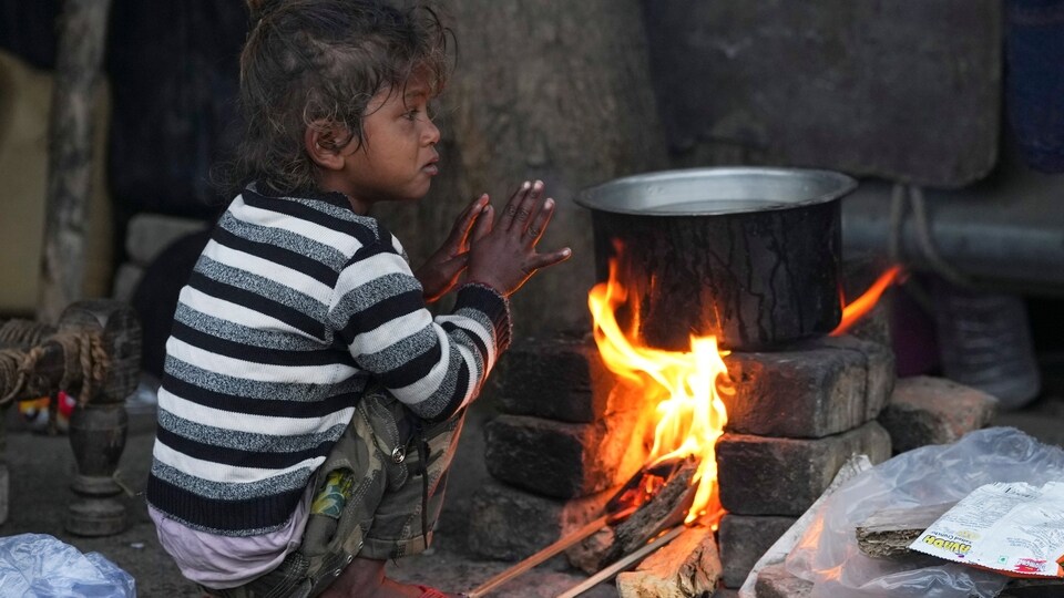
The India Meteorological Department (IMD) classifies the December-February period as the winter season in India. This means that we are over three weeks into the 2025-26 winter. How is this winter faring in terms of temperature? An HT analysis of the gridded data of the IMD shows that this December has started cooler than it usually does. Both maximum and minimum temperature are trending lower than normal so far, which is rare.
A cooler than normal start to winter 2025-26
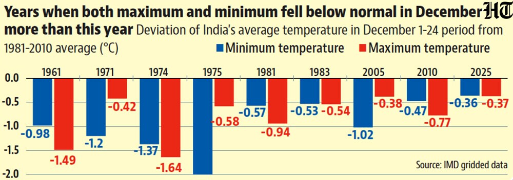
 Both India’s average maximum and minimum are below normal this winterIndia’s average maximum temperature is 25.65°C for this month up to December 24, the 24th lowest maximum for this part of December since 1951, the first year for which the gridded data is available; and 0.37°C lower than the 1981-2010 average, which IMD considers as the normal for tracking trends in temperature. The average minimum on the other hand is 11.69°C, 18th lowest and 0.36°C lower than the normal for this part of December. This means that neither maximum nor minimum are very far below normal. However, both being below normal is a relatively rare event. The last time this happened for the December 1-24 period was in 2018, although the deviation in maximum was a marginal 0.04°C that year. There have been only nine years since 1951 when the both maximum and minimum were below normal by more than 0.35°C (as is the case this year), the last such year being 2010.
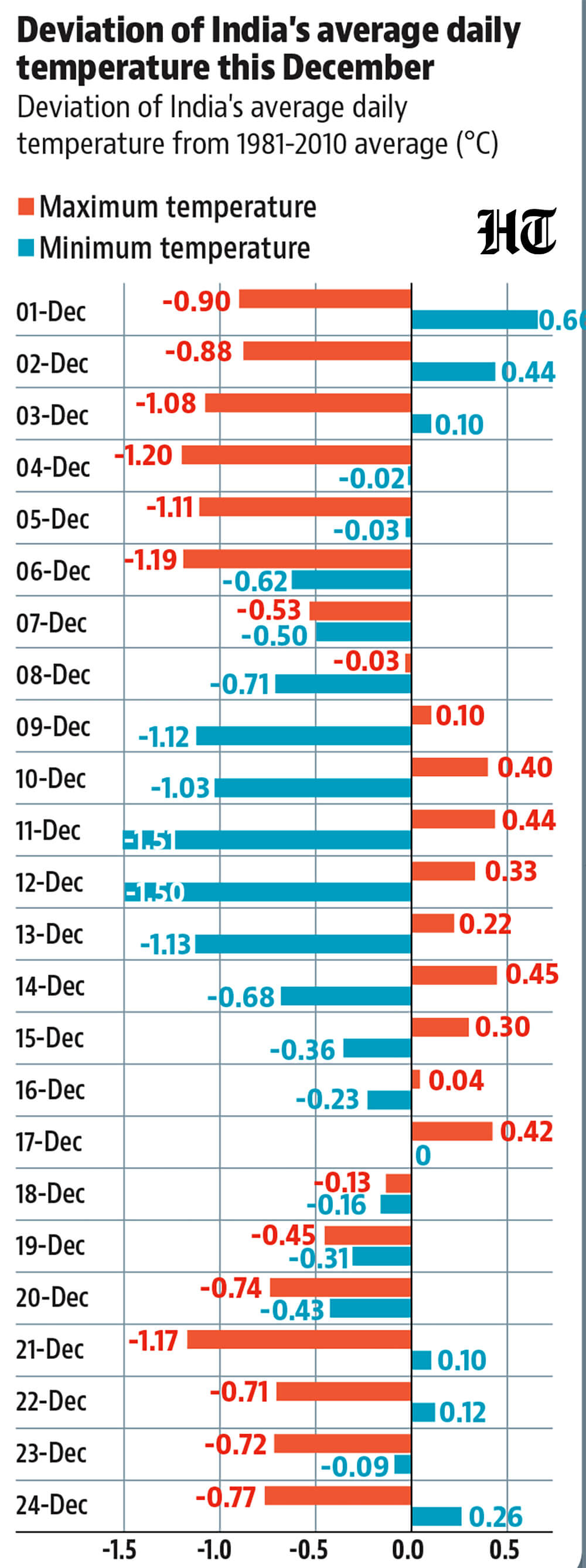
- This does not mean that both days and nights have been cold throughout the monthTo be sure, both maximum (which is an indicator of daytime temperatures) and minimum (which is an indicator of night or early morning temperatures) have been below normal simultaneously on only nine days. For example, the maximum was below normal in the December 1-8 period, above normal in the December 9-17 period, and then again below normal in the December 18-24 period. While the minimum was below normal continuously in the December 4-20 period, it fell the most below normal in the December 9-13 period, when the maximum was above normal.
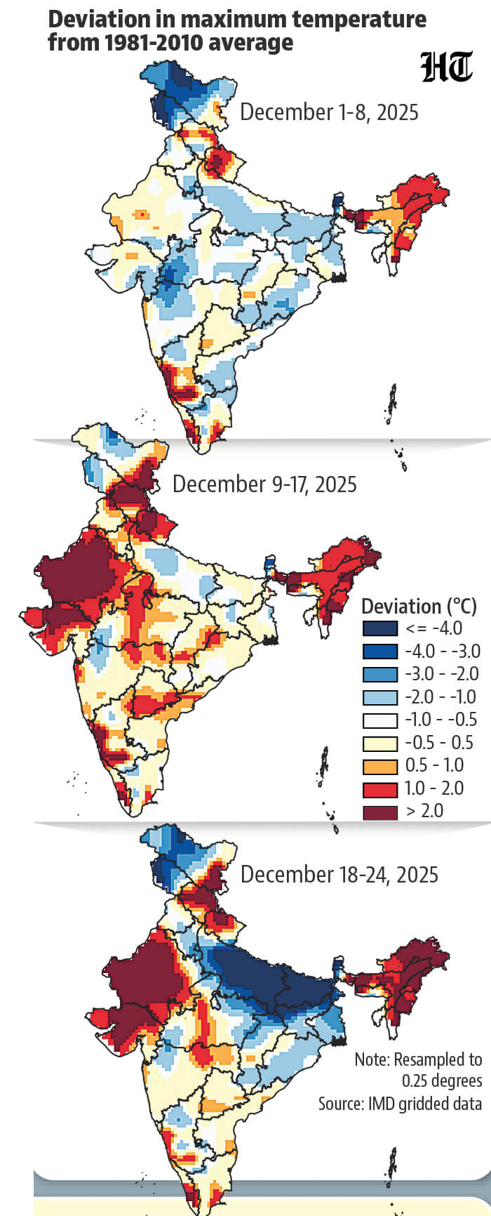
- The daily trends were created by different geographical patternsWhile two periods saw cooler than normal maximums, the geographical pattern was different . In the first week of December, maximums fell normally across the country. Moreover, the deviation was not extreme in most places. This was not the case in the past week, when maximums fell below normal in a limited area: the Indo-Gangetic plains, parts of eastern and central India, Jammu and Kashmir, and Ladakh. The maximum was cooler than normal by at least 4°C across most of Uttar Pradesh and at least 2°C cooler in Delhi and Haryana . In the December 9-17 period, India’s average maximum was above normal because Rajasthan and Gujarat were warmer than normal, and the Indo-Gangetic plains were only somewhat below normal.
- What explains these trends?The warmer than normal maximums in peninsular India after the first week are explained by rain. The region is usually rainy due to the north-east monsoon at this time, but has received little rain after the first week of December this year. This has kept the day warm and nights cool, with no clouds to trap heat. In northern India, temperatures are driven by multiple factors at this time. An approaching western disturbance – a storm originating west of India, usually in the Mediterranean region – can slow down cold northwesterly winds. However, slow surface winds accompanied with moisture can also lead to fog, which decreases maximums by preventing solar heating on the surface. This was the case, for example, in the Indo-Gangetic plains around December 20.


Unlock a world of Benefits with HT! From insightful newsletters to real-time news alerts and a personalized news feed – it's all here, just a click away! -Login Now!


