
 E-Paper



Mid-air turbulence causes Air India's Phuket-Delhi flight to drop 300 feet: Why monsoon airspace is unlike any other
Ten passengers and four crew were taken for medical checks after AI2379's sudden and brief drop. The weather it flew through may explain why

 Prefer HTon Google


An Air India Airbus A320 flying from Phuket to Delhi on Tuesday morning experienced what the airline described as a brief turbulence-related event during cruise, causing a momentary drop of 300 feet in altitude.
Flight AI2379 landed safely at Delhi at 11.15 am but ten passengers and four crew were taken for medical checks, Air India said in a statement, adding that there were no serious injuries.
On a flight data recorder, 300 feet is a small deviation, but, in the cabin, it can be violent, especially if it comes mid-cruise. The jolt a passenger feels is essentially a mismatch in inertia: when an aircraft drops sharply, an unbelted passenger continues at the altitude it was — briefly, and by a small margin — while the aircraft accelerates downward beneath it. The passenger then falls back onto the seat, the aisle, or hits the overhead bin, at whatever speed the aircraft has separated from it.
One of the key determinants of injury in such an event is whether the seatbelt sign was on and whether the passenger obeyed it.
The corridor the flight was crossing
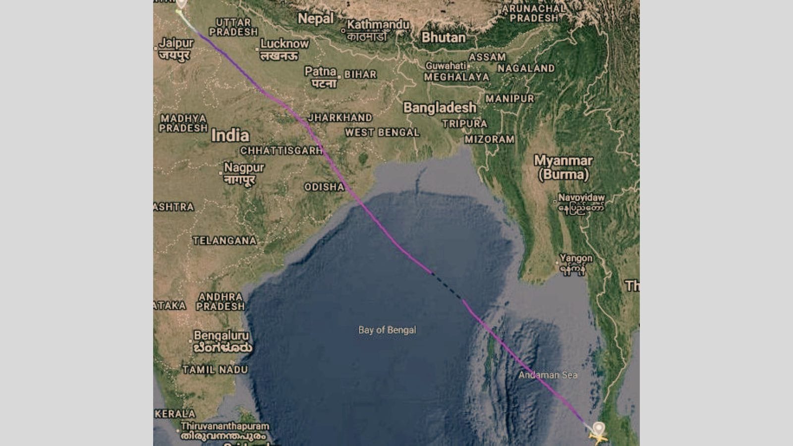
AI2379's routing took the aircraft north-northwest from Phuket across the Andaman Sea, over the Bay of Bengal, into Indian airspace along the Odisha coast, and then across central India to Delhi. In August, that corridor traverses one of the most convectively active air masses on the planet.
The monsoon trough — the low-pressure axis along which moisture-laden southwesterlies converge — sits across the Gangetic plain in August, feeding the Bay with warm, wet air over sea surface temperatures of around 28–29°C. The result is deep convection: cumulonimbus towers, the anvil-topped storm clouds that build vertically to as much as 16 kilometres and organise into mesoscale systems spanning hundreds of kilometres.
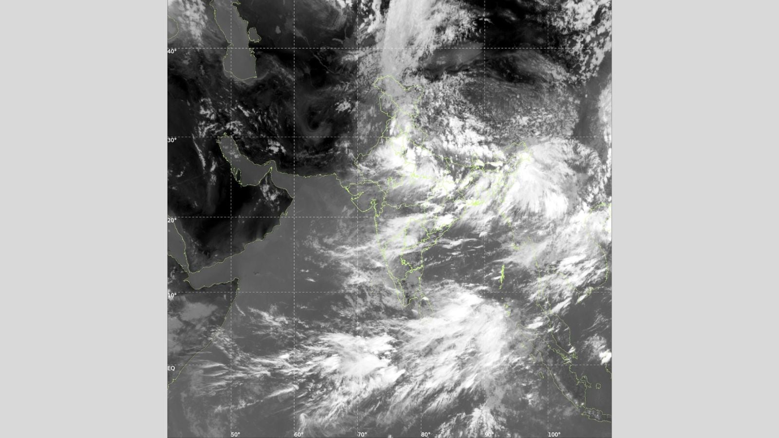
The India Meteorological Department's all-India bulletin for August 4, issued at mid-day, captures the atmosphere the flight crossed. IMD forecast fairly widespread to widespread rainfall over Odisha and Gangetic West Bengal, “extremely heavy rainfall likely at isolated places” over Assam, Meghalaya, sub-Himalayan West Bengal and Sikkim, and thundersquall winds gusting to 70 kmph over the Andaman & Nicobar Islands.
To be sure, it was not clear where exactly the turbulence struck the plane on its journey.
Planes cross monsoon systems every day of August without incident. But some points of these journeys may be trickier than others.
One is the coastal transition zone, where the moist maritime air mass meets the diurnally heated Indian landmass, which is a recognised focus of deep convection in monsoon climatology. In AI2379’s case, this was above Odisha – a region bathed in clouds according to INSAT’s satellite images.
Turbulence & why the monsoon version is different
Turbulence in aviation falls into three broad categories. Convective turbulence is generated inside and around thunderstorms — the updrafts and downdrafts of active or decaying cumulonimbus cells.
Clear-air turbulence, or CAT, is generated by vertical wind shear in the jet stream, at cruise altitudes, in cloudless air.
Mountain-wave turbulence is produced when stable air is forced over high terrain and oscillates.
Monsoon airspace over the Bay can be a convective-turbulence problem. A mature monsoon thunderstorm is not weather an aircraft can fly over — it's usually through or around, depending on a pilot's judgement. During monsoon thunderstorms, cumulonimbus towers routinely reach 16 kilometres, punching through the altitude at which airliners cruise. Inside the tower, air is rushing upward at 15 to 30 metres a second; along its edges, it is rushing back down at comparable speeds. An aircraft that clips the edge of that structure can experience air that is itself moving vertically at speeds the wings were not designed to smooth out.
Convective turbulence also extends beyond the visible cloud. A mature cell sheds its anvil — the flat, spreading cirrus top — hundreds of kilometres downwind, and turbulence can exist in the clear air around and above it, where the aircraft's radar shows nothing. Routes planned around the visible radar picture still get caught, because the atmospheric structure that produced the storm extends further than the storm.
Also read: Airlines report 352 major flight defects till June, Akasa and Air India top list
What the cockpit and dispatch can see
An airline typically has three layers of information about what lies ahead. The onboard weather radar — a forward-facing X-band system in the aircraft's nose — detects precipitation, from which the presence of a convective cell can be inferred. It does not detect dry turbulence, does not detect CAT, and suffers attenuation: a strong cell in the foreground blocks the radar's view of what lies behind it. Pilots trained on monsoon operations are taught to treat the far side of a cell as unknown.
The second layer is pilot-to-pilot. PIREPs (pilot reports) and automated EDR (eddy dissipation rate) data transmitted by aircraft that have already encountered turbulence feed a picture that dispatchers and later crews consult. The International Air Transport Association's (IATA) Turbulence Aware programme pools this data across participating airlines. Coverage is denser on transatlantic and transpacific routes than over the Bay of Bengal.
The third layer is the meteorological watch service. IMD's aviation offices at Delhi, Kolkata, Chennai and Mumbai function as meteorological watch offices for their regions and issue advisories for significant en-route weather. For instance, they flag when severe convection, turbulence, icing or tropical cyclone activity is observed or expected.
Airlines receive these advisories through international teletype networks in real time.
Together, these systems catch most of the turbulence risk before a flight runs into them. But they do not catch all of it. The onboard radar misses what it is not designed to see. Pilot reports can have gaps for airspace with less traffic, and advisories describe a hazard's expected area, not the specific cell a specific aircraft will encounter.
The warming climate threat
A warmer atmosphere holds more moisture — about 7% more for every degree Celsius of warming. And moisture is the fuel of thunderstorms. More of it means taller cumulonimbus towers, stronger updrafts, and more energetic monsoon systems.
There is also direct evidence that turbulence itself is increasing, though it comes from a different corner of the world.
Research at the University of Reading, published in Nature in 2019, found that vertical wind shear at aircraft cruising altitude over the North Atlantic strengthened by 15% between 1979 and 2017. A follow-up study in Geophysical Research Letters in 2023 found that severe clear-air turbulence over the same region rose by 55% across those four decades.
Similar analyses for Indian airspace have not been done, but the underlying physics — a warming upper atmosphere reshaping the jet stream — is not confined to the Atlantic.
None of this makes monsoon flying — as it is today with adequate planning and preparation — unsafe. Airlines are designed to withstand structural loads well beyond anything AI2379 encountered, and the systems that route aircraft around the worst of the weather — onboard radar, pilot reports, the meteorological watch — work most of the time.
When they don't and flights run into turbulence, among the simplest instruments to safeguard oneself is to simply strap the seatbelt on.


