E-Paper



The Radcliffe ‘error’ that was really a delay: Why parts of Bengal raise tricolour & celebrate ‘inclusion day’ on Aug 18
Popular accounts say Radcliffe erred and the viceroy fixed the map. The record says the boundary wasn't announced until two days after independence.

 Prefer HTon Google


On August 14 and 15, 1947, as India and Pakistan celebrated independence, Pakistan flags were hoisted in a string of Bengal towns — in Nadia’s Krishnanagar, Malda’s English Bazar, and in Balurghat, then part of the Dinajpur district. Nobody yet knew where the border ran, but some assumed East Pakistan was the likely outcome.
For the next three days, much of Murshidabad, Nadia, Malda, the old Dinajpur and the Bongaon subdivision of Jessore lived in limbo. When Sir Cyril Radcliffe’s award – details about the boundary – was finally read out on All India Radio on the evening of August 17, it turned out most of these areas were with India.
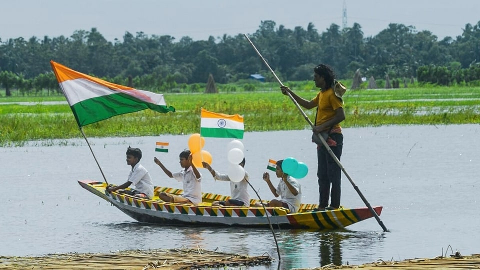
So, on the afternoon of August 18, three days after the rest of the country, the Pakistani flags came down and the tricolour went up in their place.
Communities in these belts still observe August 18 as Bharat Bhukti Dibas, or the Day of Inclusion. In Nadia’s Shibnibas, locals mark it with commemorative flag-hoistings and traditional boat races on the Churni River. In Balurghat, now the headquarters of South Dinajpur, the day is observed as a parallel Independence Day.
Historian Samit Ghosh told Millennium Post in a 2024 feature that it’s for this reason that August 18 “holds a special place” in the history of the region.
Also read: Freedom the same night, but different dates: Why Pakistan marks its Independence Day on August 14
Why this happened?
The popular explanation goes back to Radcliffe, the British lawyer with no prior experience of India who was given about five weeks to divide Bengal and Punjab between India and Pakistan before independence.
In lore, Radcliffe drew a line that mistakenly handed several Hindu-majority tracts to East Pakistan, and Lord Louis Mountbatten, the then viceroy of British-ruled India, ordered him to redraw the map after urgent appeals. The ‘corrected’ border was announced on the night of August 17, and the tricolour went up the next morning.
But scholarly records tell a different story.
Radcliffe had signed his report on Bengal’s division on August 12, 1947, and the viceroy possessed the details before either India or Pakistan celebrated independence. The details of the boundary, though, were not published until August 17, when they appeared in The Gazette of India Extraordinary.
The delay was deliberate.
A 2022 essay by the Centre for Law and Policy Research's Constitution of India project, drawing on Mountbatten’s ‘Top Secret and Personal' reports to the King and the British government, records that the viceroy was advised against revealing the boundary before Independence Day. The idea was that disclosure of the boundary would derail the ceremonies in Karachi on August 14 and Delhi on August 15, and risk aggravating communal violence already spreading across Punjab.
Mountbatten took this advice, going without disclosing any information about the boundaries.
The Cambridge historian Joya Chatterji, in her 1999 paper ‘The Fashioning of a Frontier: The Radcliffe Line and Bengal's Border Landscape, 1947-52’ in Modern Asian Studies, has argued that Radcliffe had tracked several of the arguments put to him before marking down the boundary. Among these was the case that the viability of the Hooghly river depended on retaining Murshidabad, and much of the Nadia river system, in West Bengal, India.
Neither her account nor the published Transfer of Power correspondence to the British government by the colonial administration records any instruction from Mountbatten to Radcliffe to redraw the Bengal line between August 14 and August 17.
Uncertainty in the vacuum
The three-day silence left the ground open to speculation. In Krishnanagar, English Bazar and Ranaghat, Muslim League workers hoisted Pakistan flags on August 14 or August 15 in anticipation. The demographic case was not implausible: Murshidabad is Muslim-majority, substantial parts of Nadia were too, and Malda’s population was mixed.
Some households, uncertain whether they were about to become minorities in a new state, took their own precautions. Recollections passed down in Nadia and Malda speak of blackouts at night and of women halting cooking for two days to avoid being caught in any communal violence.
In Balurghat, the tussle over the flagstaff turned violent. Ghosh told Millennium Post that units of the Gorkha regiment clashed with Pathan and Baloch troops between August 15 and August 18. The town remained a “notional area” until the Bengal boundary was read out on radio on the evening of August 17.
The terms revealed that Radcliffe had assigned the whole of Murshidabad to India, together with the greater part of Nadia.
Only three Muslim-majority subdivisions of Nadia — Meherpur, Chuadanga and Kushtia — went to East Pakistan. Parts of Malda, Dinajpur and Jalpaiguri were split between the two countries, and the Bongaon subdivision of Jessore was folded into what was then the undivided 24 Parganas district.
On the other side of the border, Khulna — Hindu-majority by a narrow margin — went to Pakistan, along with parts of Jessore that Hindu petitioners had argued for.
The Asiatic Society of Bangladesh notes that Radcliffe’s boundary drew protests from both the sides, but, for the towns that gathered under the tricolour on August 18, 1947, the day marked the end of a silence — the moment they learned which country they were in.