On Saturday the India Meteorological Department declared that the southwest monsoon has withdrawn from some parts of West Rajasthan, marking the first retreat of the 2026 season.
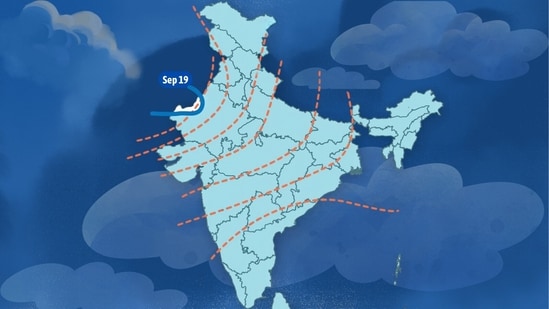
The line of withdrawal runs from a point over the desert at 27.0°N/68.0°E, past Ramgarh, Mohangarh, Phalodi and Khajuwala, to 29.5°N/71.5°E. The IMD said it expects the line to move further over the next three to four days, covering more of Rajasthan and parts of Punjab and Saurashtra & Kutch.
The normal date for this first declaration is September 17, which puts the season two days behind, well inside the ordinary year-to-year spread.
Monsoon withdrawal involves multiple factors for the IMD to represent as an arc on the country's map, which is the inverse of the monsoon onset map. The arc is based on a set of measurements, each of which has to hold for five days before the department will declare monsoon withdrawn from there. These measurements represent the onset of dry, northwesterly winds – the opposite of the system that has pulled moist air onto the subcontinent since June.
The arc
The IMD keeps the arc continuous and moves it as conditions allow, which is why Saturday's version ran through four small towns in western Rajasthan rather than around a scatter of dry districts.
{{/usCountry}}The IMD keeps the arc continuous and moves it as conditions allow, which is why Saturday's version ran through four small towns in western Rajasthan rather than around a scatter of dry districts.
{{/usCountry}}The monsoon covered the country in the opposite direction. It sets in over Kerala around June 1, spreads north and west over the following six weeks, and reaches the Rajasthan desert in early July. Withdrawal follows that map backwards, beginning in the northwest and travelling southeast over roughly four weeks.
The department expects to declare full withdrawal from the whole country around October 15, by which point the winds over the southern peninsula have changed over from the southwesterly regime that defines the season.
The measurements
The IMD tests three conditions before it declares a withdrawal, and assesses all of them after the event rather than in advance.
The assessment for withdrawal only begins after September 1. When it does, the Met department checks if rainfall stopped over the area for five continuous days, whether an anticyclone is established in the lower troposphere at 850 hPa and below, and if there a “considerable reduction in moisture content” as seen in satellite imagery and in tephigrams.
Tephigrams are vertical profiles of temperature and humidity through the depth of the atmosphere, taken by weather balloon. Anticyclone is an area of high pressure within which air descends instead of rising.
Every further step of the arc has to clear those three tests again. The newly withdrawn area must adjoin the area already withdrawn, which is what keeps the boundary continuous, and it must have had its five dry days and its fall in atmospheric moisture.
Also read: Chandigarh: With 15% rain deficit, monsoon withdrawal likely in three days
Does rain stop?
Rain can still be recorded over an area the monsoon has formally left. The usual source for rainfall over northern India is a western disturbance, which is a low-pressure system that travels east from the Mediterranean and the Caspian and brings rain to the plains and snow to the hills through the colder months in India. Withdrawal takes the monsoon circulation out of the area and leaves the rest of the weather working.
The country can also be drying in one corner and raining in anotherr. The IMD's bulletin on Saturday flagged a low-pressure area forming over the Andaman Sea, at the other end of the country from the arc.
What triggers the change
The same factor that triggers all season changes. The Earth's axis is tilted about 23.5 degrees away from the perpendicular to its orbit, which is what gives the planet its seasons. Through the northern summer, the Sun stands directly overhead somewhere between the equator and the Tropic of Cancer.
During this time, the heated land builds an area of intense low pressure over northwest India and Pakistan, and moist air flows inland towards it from the warm seas on either side. Mumbai's afternoon sea breeze comes from that difference. Air over the heated land rises, cooler sea air flows in behind it, and at night, once the land has cooled below the sea, the breeze reverses. The southwest monsoon is that circulation scaled to a subcontinent and slowed to a year.
By late September, it has moved back to the equator, so that noon sunlight reaches northern India at a lower angle and the days grow shorter. The region takes in less solar energy every week through September, thus becoming cooler.
As the land, the heat low weakens and the pressure difference between land and sea flattens. The southwesterly winds lose what had been pulling them inland, and high pressure builds over the northwest in place of the low.
The wind over the desert is the first to turn around. Instead of moist air off the Arabian Sea, the region now gets dry air off the land, moving in from the northwest.
The circulation higher up in the atmosphere too switches back over September and October. The subtropical westerly jet, which is a band of fast winds about 10 km above the surface, had moved north of the Himalayas in June. It now returns south across the north Indian plain, and the sinking air beneath it reinforces the high pressure at the surface. High pressure winds are always drier.
The monsoon trough moves south as well. This is the elongated belt of low pressure that lies across the Gangetic plain through the season, marking where moist air converges and rises, and its position from week to week governs where the heaviest rain falls. As the Sun moves south, the trough follows it towards the equator and the convergence goes with it.
Northwest India feels all of this first. The region is the farthest point the monsoon reaches and the last to be covered on the way in, which makes it the first to be given up. It is the driest and most thermally extreme part of the country, so it cools fastest once the sunlight weakens. And at 26 to 30 degrees north, it loses far more September sunlight than the peninsula, which lies closer to the equator.
What pushes the arc
In 2024, Akshay Deoras, a research scientist at the University of Reading and the National Centre for Atmospheric Science, and three colleagues published work in the Quarterly Journal of the Royal Meteorological Society on what pushes the monsoon out, a question that had drawn far less scientific attention than the onset.
They describe a wedge of dry air from the mid-latitudes. It lies over India before the monsoon and is driven back towards eastern Pakistan as the rains advance. Around the middle of September it returns over northwest India, thickest at about 15,000 feet above the ground.
Dry air does particular damage to a growing cloud. Mixed into the rising column, it evaporates the water droplets, and evaporation draws heat out of the air doing the rising. That air cools, loses the buoyancy that was lifting it, and stops climbing.
Deoras has said the intrusion "first appears over northwest India around mid-September", creating the least favourable conditions anywhere in the country for thunderstorms at precisely the point where withdrawal begins. Over the following weeks the wedge thickens, descends and pushes further across the country, until by the middle of October it covers most of India and the monsoon leaves entirely.
Before this work, there was no conceptual model for why the retreat travels southeast.
Also read: Dry weather likely in Himachal from September 22, mercury to rise: IMD
Why the normal date moved
The IMD revised its normal onset and withdrawal dates in 2020. The dates it had used until then were based on 149 stations observing between 1901 and 1940. The new withdrawal dates were computed from the department's own declarations over the far better observed period from 1971 to 2019.
The department recorded “appreciable changes” over northwest and central India, with the monsoon leaving the region seven to 14 days later than the old figures had it. Jaisalmer and Bikaner, both on the arc drawn on Saturday, moved from 1 September to 17 September, a shift of 16 days. Hyderabad, Kolkata and Guwahati moved a day or two in the other direction.
Some of that gap reflects the change in the observing network and the reference period rather than a change in the weather, and the IMD makes no climate claim for the revision. Stronger evidence for a trend comes from a 2025 paper in Mausam, the department's own journal. Its authors found the length of the monsoon season across the country growing by 1.6 days per decade between 1971 and 2020, while the onset over Kerala showed no significant change across those five decades. The lengthening has come at the end of the season rather than the beginning.
What the retreat sets in motion
Kharif crops are harvested through September and October as the rains retreat. Late rain on a standing mature crop damages it, so an orderly withdrawal matters as much as a generous season.
Over the southern peninsula the retreat brings a second reversal. The winds turn northeasterly, cross the Bay of Bengal and pick up moisture, and Tamil Nadu, coastal Andhra Pradesh and parts of Karnataka and Kerala receive their main rains between October and December.
Over the northern plains it brings the pollution season. The dry northwesterly winds that replaced the monsoon come off Punjab and Haryana, where paddy residue is burned after the harvest, and they carry the smoke towards Delhi. The sinking air that stopped the rain also lowers the height of the layer within which pollutants mix, and weakens the winds that would otherwise carry them away.
Research published in npj Clean Air last year found that layer over Delhi and its neighbouring districts roughly halving between early October and late November, which cut the region's ventilation, the rate at which air moves pollutants out, by a factor of three. Gufran Beig, then founder project director of the air quality forecasting system Safar, said of the 2021 season that a delayed withdrawal had pushed the peak pollution period into November.
The season now closing has run short of normal. The IMD forecast 90% of the long period average in late May, below normal, and put the probability of a deficient year at 60%. A strong El Niño, which is the periodic warming of the eastern and central Pacific, has held through the monsoon months, and El Niño years tend to suppress Indian rainfall, though not reliably enough to forecast from on their own. Working the other way this year is a developing positive Indian Ocean Dipole, a warming of the western Indian Ocean relative to the east, which draws moisture towards the subcontinent. Cumulative rainfall for the country is running about 15% below normal.
How fast the arc moves over the next fortnight depends in part on the system now developing over the Bay of Bengal, which could push moisture back across central India before the dry air finishes its work.