
 E-Paper



West Bengal, Odisha brace as Cyclone Sitrang approaches
While the Bengal government has begun planning the evacuation process in low-lying areas in several districts, Odisha has raised the level of alertness in several of its coastal districts, officials in both states said.

 Prefer HTon Google


Cyclone Sitrang, the first cyclonic storm in the north Indian Ocean after the monsoon, is likely to reach the coasts of West Bengal and Bangladesh on Tuesday, causing widespread rainfall over Bengal as well as Odisha around Kali Puja-Diwali, the India Meteorological Department (IMD) said on Friday.

Several global models have indicated that the weather system is likely to intensify into a severe cyclone with a speed of 100-110kmph before making landfall over Bangladesh coast on Tuesday, it added.
While the Bengal government has begun planning the evacuation process in low-lying areas in several districts, Odisha has raised the level of alertness in several of its coastal districts, officials in both states said.
Also Read| Cyclone Sitrang: These states are likely to receive heavy rainfall from Monday
Kali Puja will be celebrated on Monday and Diwali on Tuesday in the two states.
A low pressure area formed over north Andaman Sea and adjoining areas of South Andaman Sea and Southeast Bay of Bengal on Thursday persisted on Friday.
According to the weather body, the system is likely to move west-northwestwards and concentrate into a depression over southeast and adjoining east central Bay of Bengal on Saturday. While moving northwestwards, it is expected to intensify into a deep depression over east-central and adjoining southeast Bay of Bengal on Sunday.
Subsequently, it is likely to recurve northwards gradually before intensifying into a cyclonic storm over west central and adjoining east central Bay of Bengal on Monday. Thereafter, it is likely to move north-northeast wards and reach near West Bengal-Bangladesh coasts on Tuesday, skirting the Odisha coast, the weather body said.
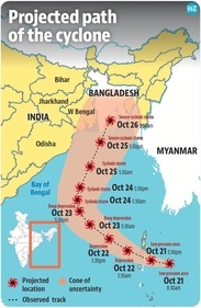
“As of Friday, (global weather) models are suggesting that the cyclone will make landfall over the Bangladesh coast. But it will definitely impact the adjoining West Bengal coasts, especially 24 Parganas. Though the sea surface temperature is above normal over the Bay of Bengal, where Sitrang is developing, the region has been recording rains, so the water is getting cooled. This may prevent its further intensification to a very severe cyclone,” explained Ananda Kumar Das, IMD’s cyclone monitoring division in-charge.
“But heavy rain with strong winds will impact Odisha and West Bengal coasts starting October 24. Local residents should be prepared,” he said, adding that cyclones in the post-monsoon season have proven to be more severe over the last 20 years than those in the pre-monsoon period.
The name Sitrang was suggested by Thailand.
Gale wind speed reaching 70-80 kmph, gusting to 90 kmph, is likely over west central and adjoining areas of east central and north Bay of Bengal on Monday, the IMD said. Squally wind speed reaching 45-55 kmph, gusting to 65 kmph, is very likely along and off the coasts of Odisha and West Bengal.
On Tuesday, the wind speed is likely to increase to 90-100 kmph, gusting to 110 kmph, over north and adjoining central Bay of Bengal and along and off West Bengal and Bangladesh coasts. Squally wind speed reaching 50-60 kmph, gusting to 70 kmph, is likely along and off the Odisha coast.
Gale wind speed reaching 90-100 kmph, gusting to 110 kmph, is likely over north Bay of Bengal and along and off West Bengal and Bangladesh coasts till Wednesday (October 26) morning, the IMD predicted.
The system is likely to trigger widespread light to moderate rainfall, with isolated heavy rain and thunderstorms accompanied by lightning over Tamil Nadu, Puducherry, Karaikal, Kerala and Mahe till October 23.
Also Read| Odisha issues alert to 7 districts over possible impact of Cyclone Sitrang
Widespread rainfall with isolated heavy rain and thunderstorm and lightning is also likely over Odisha from October 23 to 25 and Gangetic Bengal from October 24 to 26.
In view of the weather developments, Bengal chief minister Mamata Banerjee convened an emergency meeting at state secretariat ‘Nabanna’ on Friday to take stock of the preparedness. Chief secretary HK Dwivedi also held a meeting with senior officials of south Bengal districts.
“Preparations have already started. The flood shelters are being readied. Essential items such as food, medicines and drinking water are being stored. Announcements are being made to warn fishermen not to venture into the sea and those who have already gone out have been advised to return,” said PK Maji, district magistrate of East Midnapore, a coastal district.
The state had recorded two major cyclones in two consecutive years – Amphan in May 2020 and Yaas in May 2021. The two cyclones had hit the Sundarbans, the world’s largest mangrove forest straddling India and Bangladesh. It also left a trail of death and enormous destruction.
“Preparations are underway in full swing. The evacuation process will begin from Sunday. We have started making announcements to make people aware about the cyclone,” said Dipankar Halder, district disaster management officer of North 24 Parganas.
In Kolkata, mayor Firhad Hakim also held a meeting on Friday. Road clearing and tree-cutting machines and water pumps were being readied. The leaves of all district magistrates, superintendents of police and emergency department workers were cancelled as a part of the preparedness.
In Odisha, special relief commissioner Pradip Jena held an emergency meeting. “We have asked the Odisha Disaster Rapid Action Force, National Disaster Response Force, fire service, Navy, Coast Guard and district officials to remain on alert as the system, while passing the Odisha coast, is expected to trigger heavy rains in several coastal and interior districts,” he said.
“The leaves of concerned government employees have been cancelled and they have been asked to remain present in their respective headquarters,” he added.
The government is yet to decide on the evacuation process.
The state health and family welfare department also issued an advisory to all municipal commissioners, district collectors, Capital Hospital in Bhubaneswar, Rourkela General Hospital, all chief district medical officers and superintendents of all government medical colleges and hospitals.
“Pregnant women expecting delivery in the next 10 days should be shifted to the nearest government hospital having safe delivery facilities,” said commissioner-cum-secretary of health, Shalini Pandit.
Widespread light to moderate rainfall with isolated heavy rain and thunderstorm or lightning is also very likely over Assam, Meghalaya, Nagaland, Manipur, Mizoram and Tripura from October 24 to 26, and Arunachal Pradesh on October 25.
Isolated very heavy rainfall is expected over Assam, Meghalaya, Nagaland, Manipur, Mizoram and Tripura on October 25 and 26, the weather body said.



