
 E-Paper



Delhi receives moderate rain but monsoon deficit yet to reduce
Safdarjung, Lodhi Road and Palam received 24.2mm, 27.8mm and 23mm of rain on Tuesday respectively, according to the Regional Meteorological Centre. These stations received 1-2 cm rain in the short span of 45 minutes according to RMC, Delhi.

 Prefer HTon Google


The national capital received some “moderate” spells of rain for an hour on Tuesday afternoon, leading to waterlogging and traffic disruption in several areas.
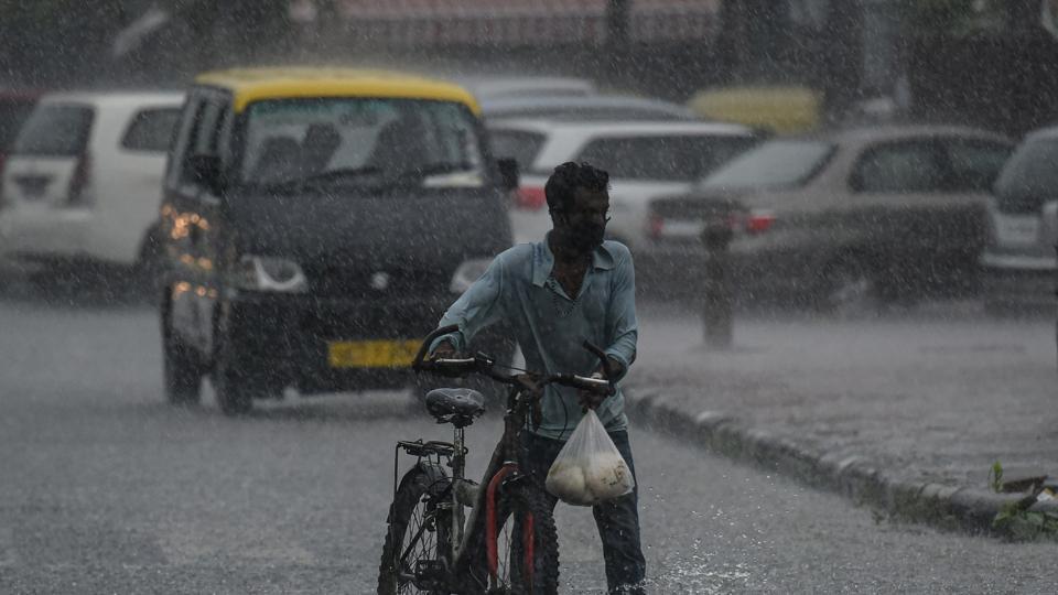
Safdarjung, Lodhi Road and Palam received 24.2mm, 27.8mm and 23mm of rain on Tuesday respectively, according to the Regional Meteorological Centre. These stations received 1-2 cm rain in the short span of 45 minutes according to RMC, Delhi.
“We received moderate rain within a short period of half an hour to 45 minutes. There may be more rain later tonight (Tuesday night) or on Wednesday early morning. This rain is a combination of factors. The monsoon trough (a line of low pressure) is passing through Ganganagar in Rajasthan, Delhi, Hardoi in UP, Gorakhpur and the northeastern states. There is also a trough in the westerlies bringing rain here. The monsoon trough will shift slightly northwards but light rain is likely to continue over Delhi,” said Kuldeep Shrivastava, head of the regional weather forecasting centre.
Delhi’s rainfall deficiency (since June 1) was 43% on Tuesday morning but is likely to have reduced by Tuesday evening after the spell of rain.
Early Tuesday morning, moderate rain was recorded at Ayanagar, which received about 34mm rain, and heavy rain was recorded at Faridabad, which received about 80 mm rain around the same time. Rainfall between 64.5mm and 124.4mm in a day is considered ‘heavy” rain by IMD.
IMD, in its Tuesday bulletin, said the western part of the monsoon trough is near its normal position and the eastern part is along the foothills of the Himalayas. Besides, the convergence of moist southerly-southwesterly winds from the Bay of Bengal over the north-east and east of India and from the Arabian Sea over the north-west of India at lower tropospheric levels is likely to continue for the next two days.
Under the influence of these meteorological conditions, widespread and heavy rain is likely over Jammu and Kashmir, Ladakh, Gilgit-Baltistan, Muzaffarabad, Himachal Pradesh, Uttarakhand, Punjab, Haryana, Chandigarh, Delhi and Uttar Pradesh till Wednesday.
Widespread and very heavy rain is also likely over Bihar, Jharkhand, Sub-Himalayan West Bengal, Sikkim, Arunachal Pradesh, Assam, Meghalaya, Nagaland, Manipur, Mizoram and Tripura in the next three or four days and the intensity of rainfall is very likely to decrease thereafter.
FLOODS IN ASSAM, MEGHALAYA
As on Monday, 30 stations (15 in Bihar, 10 in Assam, 3 in Uttar Pradesh, 1 in Arunachal Pradesh and 1 in West Bengal) were categorised as ‘severe flood situation’, according to the Central Water Commission.
Siang river at Pasighat in East Siang district continues to flow in ‘severe flood situation’ with heavy rainfall in its catchment. Due to forecasted rainfall in the next three days, there is a likelihood of a rapid rise in water levels in rivers Siang, Lohit, Dibang, Subansiri, Kameng and Noa-Dehing, CWC has warned. The Brahmaputra continues to be in ‘severe flood situation’ all along its course from Dibrugarh to Dhubri. Due to forecasted rainfall, there is a likelihood of ‘severe to extreme flood situation’ in the main Brahmaputra from Dibrugarh to Dhubri districts. Some rivers in Sub-Himalayan West Bengal, including rivers flowing from Bhutan—Teesta, Jaldhaka, Torsa and Raidak—are expected to rise rapidly in the next two or three days. A ‘severe flood situation’ is declared when the water level touches or exceeds the danger level but is below the ‘highest flood level’ (HFL). Floods in Assam have already killed at least 80 people and affected over 70 lakh, according to the state government.
In the north, there could be a sudden rise in the Sutlej, Yamuna, Alaknanda, Bhagirathi, Ramganga, Ghaghra, Sharda and Rapti rivers, CWC has warned.
“Uttarakhand’s Ramnagar has received 29cm rain on Monday which is in the ‘extremely heavy rain’ category. Many parts of Meghalaya and Arunachal Pradesh have been receiving ‘extremely heavy rain’ for three days now ranging up to 39cm a day, which is why there is flooding,” said RK Jenamani, senior scientist, national weather forecasting centre.
‘Moderate to severe’ thunderstorm and lightning is likely over Haryana, Chandigarh and Delhi, north-west Uttar Pradesh, east Uttar Pradesh, Bihar, east Madhya Pradesh, Vidarbha, Jharkhand, West Bengal, Meghalaya and north Odisha on Wednesday.
Monsoon rain over the country is over 7% with an excess of 15% over the east and north-east of India, with a -17% deficiency over north-west India, an excess of 6% over central India and an excess of 19% over the southern peninsula.
“Rain in the foothills is likely to reduce gradually in the next two days and the rain belt over central India will increase gradually,” said M Mohapatra, director general, IMD.


