
 E-Paper



Cyclone Ditwah: When will the storm make landfall? IMD issues update, 5 states on alert
Cyclonic Storm Ditwah is moving north-northwest over Sri Lanka and the Bay of Bengal, expected to approach Tamil Nadu and south Andhra Pradesh by November 30.

 Prefer HTon Google


Cyclonic Storm Ditwah, currently swirling over coastal Sri Lanka and the adjoining southwest Bay of Bengal, is steadily tracking north-northwest and is expected to move closer to the Tamil Nadu and south Andhra Pradesh coasts by the early hours of November 30, according to the India Meteorological Department (IMD).
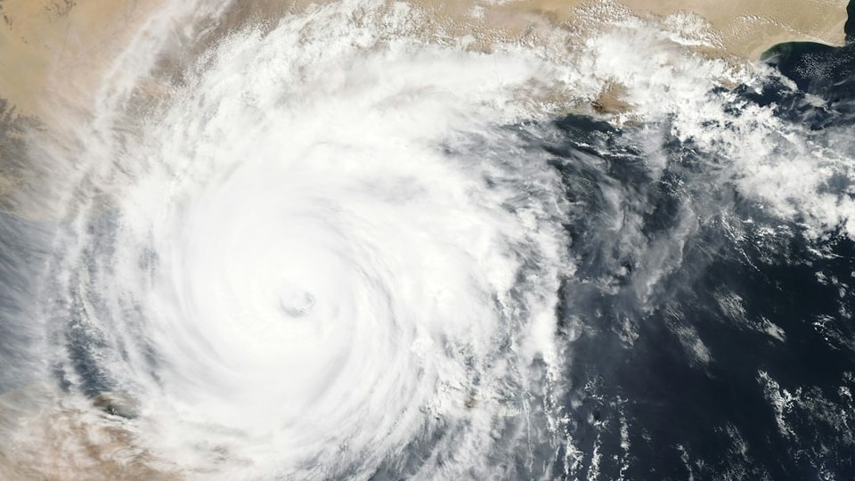
As of 5:30 am IST, the storm was positioned near 8.2 degrees North, 81.1 degrees East, roughly 50 km south-southwest of Trincomalee, 90 km northwest of Batticaloa, and 230 km north of Hambantota in Sri Lanka, the agency said. On the Indian side, Ditwah was located about 440 km south-southeast of Puducherry and 540 km south of Chennai, advancing at a modest 7 kmph over the past six hours.
Follow LIVE updaes on Cyclone Ditwah here
The system is expected to continue its north-northwestward trajectory across Sri Lanka’s coast and emerge over the southwest Bay of Bengal, before nearing the North Tamil Nadu, Puducherry, and adjoining south Andhra Pradesh coasts by early November 30.
ALSO READ | Cyclone Ditwah heads toward Tamil Nadu–Puducherry coast; IMD issues red alert in 4 districts
ALSO READ | ‘Brrrr, Bangalore is freezing’: People experience winter chills as mercury dips in Bengaluru
Rainfall to intensify across southern states
The storm, along with the associated deep depression, is set to trigger widespread rain across southern India:
Tamil Nadu: Heavy to very heavy rain is expected between November 28 to 30, with isolated extremely heavy downpours today and tomorrow.
Rayalaseema: Rainfall will persist from November 28 to December 1, with extremely heavy spells possible on November 30.
Coastal Andhra Pradesh and Yanam: Heavy to very heavy rainfall likely from November 28 to December 2, peaking on November 30.
Kerala and Mahe: Heavy rain expected today and tomorrow.
Telangana: Isolated heavy rain on November 30 and December 1.
South Interior Karnataka: Heavy rainfall possible on November 29.
Thunderstorms accompanied by lightning are likely across several regions, including Tamil Nadu (Nov 28 to Dec 1), Kerala and Mahe (Nov 28 to 29), Coastal Andhra Pradesh and Yanam (Nov 28 to Dec 1), South Interior Karnataka (Nov 29 to 30), and North Interior Karnataka (Nov 30).
The Andaman and Nicobar Islands may also experience thunderstorms with gusty winds of 30 to 40 kmph today and tomorrow, the IMD said.
ALSO READ | Cyclone ‘Ditwah’ forms after ‘rarest’ storm Senyar, may hit Tamil Nadu coast soon, says IMD
Temperature outlook
Northwest India: Minimum temperatures are set to rise by 2 to 3 degrees Celsius over the next two days before dipping again.
Central India: Temperatures will fall by 2 to 3 degrees Celsius over the next two days.
East India: A gradual 2 to 3 degrees Celsius rise is expected over the next three days.
West India: No major change for the next 24 hours, followed by a 2 to 3 degrees Celsius drop over the next four days.
Northeast India: No significant change expected for the next five days.
Fog and cold wave alerts
Dense fog: Likely during early mornings in isolated pockets of Himachal Pradesh and Haryana-Chandigarh-Delhi between November 28 to 30, and over East Rajasthan between November 30 to December 1.
Cold wave: Expected in parts of Punjab on November 28 to 29, and in Rajasthan on December 3 to 4.
Authorities are closely monitoring the system as Cyclone Ditwah continues its journey toward the Indian coastline. Fishermen have been advised not to venture into the southwest Bay of Bengal and along the Sri Lanka coast. Coastal residents are urged to stay alert and follow official advisories as rainfall intensity increases.


