
 E-Paper



Gloves are on: Cold wave grips Delhi
Delhi logged a record cold spell of 18 days last year when maximum temperatures were significantly below normal continuously.


Delhi’s minimum temperature fell to 4.1° Celsius in the early hours on Tuesday, bringing December’s first cold wave condition, according to meteorological department data that also showed that the Capital also recorded a “cold day” since the high settled at 19.4°C, significantly lower than what is normal for this time of the year.
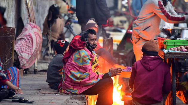
The cold, which began setting in from Monday evening, has gripped several parts of northern India, arriving as frosty winds from snow covered mountains. Tuesday’s minimum was a 4.3°C drop from the day before.
The all-time lowest minimum temperature recorded in the city is 0°C on December 27, 1930. Last year, Delhi had recorded a minimum of 2.4°C on December 28.
“There have been intense western disturbances which have brought widespread snowfall to the western Himalayas. Now icy winds are blowing over Delhi from that region. Climatologically, minimum temperatures typically fall sharply after December 15 but this year the drop has been abrupt,” said Kuldeep Shrivastava, head, regional weather forecasting centre.
“During the next three days, we are expecting several parts of northwest India including Delhi to record both cold to severe cold days and cold wave. There are mostly clear skies and chilly winds blowing which is causing both day and night temperatures drop sharply. But in some places over Punjab and Haryana we are noticing uplifted fog, which also causes day temperatures to drop as sunshine doesn’t warm the surface,” added Shrivastava.
The maximum temperature on Tuesday was recorded at 18.5°C at Safdarjung, 5°C below normal and 16.7°C at Palam, 7 degrees below normal.
According to IMD, a “cold day” or “severe cold day” is considered based on two parameters—a minimum temperature of under 10°C and if maximum temperature is 4.5°C or 6.4°C below normal respectively.
A cold wave occurs in plains when the minimum is 10 degrees or below and/or is 4.5 notches lower than the season’s normal for two consecutive days. Cold wave is also declared when the minimum temperature is less than 4 °C in the plains. A cold day and cold wave together means the gap between day and night temperatures was lower than normal.
Delhi logged a record cold spell of 18 days last year when maximum temperatures were significantly below normal continuously. There was a cold spell for 17 days in 1997 and eight days in 2014. This time too there can be a cold spell for four days until December 19, Shrivastava said.
Many parts of northwest India are recording “severe cold day” conditions since Sunday. They were markedly below normal (-5.1°C or less) at most places over Punjab and Haryana, Chandigarh, and Delhi; at many places over west Madhya Pradesh; central Maharashtra and west Rajasthan and at isolated places over Jammu & Kashmir, Ladakh, Gilgit-Baltistan, Muzaffarabad, East Madhya Pradesh and Himachal Pradesh, according to IMD. Severe Cold Day conditions were observed in pockets of Punjab and Haryana, Chandigarh and Delhi.
Cold day conditions are very likely in some pockets over Punjab, Haryana, Chandigarh, Delhi, north Rajasthan and West Uttar Pradesh during next two days, IMD said in its bulletin on Tuesday. Cold wave conditions are very likely in some pockets of Punjab, Haryana, Chandigarh, Delhi, West Uttar Pradesh and north Rajasthan during the next four days.
“When there is incursion of such cold air from the hills both day and night temperatures drop. This will continue for at least next 3-4 days,” said K Sathi Devi, head, national weather forecasting centre.
The average air quality index (AQI) reading in Delhi was at 230 at 4pm on Tuesday, falling in “poor” category. Scientists said the air is likely to improve due to relatively strong northwesterly winds. Air quality is likely to remain in “moderate/; category on December 16 and 17. “The wind speed is about 12 kmph but we are expecting it to pick up further which will be favourable for dispersal of local pollutants,” added Shrivastava.


