
 E-Paper



Rain hits Delhi, Met forecasts more
The maximum temperature dropped to 34.5 degrees Celsius (°C), nearly four degrees less than Sunday’s high of 38.6°C


Delhi received light showers on Monday owing to the residual effects of cyclone Biparjoy, which cooled the city considerably and improved air quality, but led to high humidity.
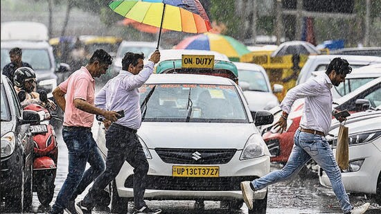
Spells of rain were witnessed across the national capital region, both in the early hours of the day and in the afternoon. This brought the maximum temperature down to 34.5 degrees Celsius (°C), nearly four degrees less than Sunday’s high of 38.6°C. However, a rise in humidity levels — which oscillated between 62% and 97% in the last 24 hours — made it a muggy day.
Delhi’s air quality, meanwhile, remained in the “moderate” category but was the best since March 31 this year with a reading of 75, data collated by HT showed. On March 31, the air quality index (AQI) stood at 73.
Similar weather conditions are likely to persist on Tuesday with light rains. The India Meteorological Department (IMD) forecast drizzling in some parts on Wednesday. A change in wind direction to easterly by the weekend is also expected to bring more rain on Saturday and Sunday, Met officials said.
“We have moisture coming into Delhi-NCR from northeast Rajasthan, where the cyclone was present in the form of a depression on Sunday. It has further weakened to a low-pressure area, but moisture keeps coming towards Delhi-NCR and beyond, with chances of some more rain till Wednesday,” said Kuldeep Srivastava, scientist at IMD.
After rainfall was recorded early in the morning, a strong thunder cell began developing over Haryana after 1pm, which gradually moved towards Delhi, bringing showers over Gurugram and parts of Delhi in the evening, the official said. However, a combination of high humidity and absence of strong winds through the day meant that it felt warmer than it was.
At 2.30pm on Monday, the heat index (HI) or “real feel” stood at 42°C, owing to an air temperature of 33.4°C and a relative humidity of 64%. A day earlier, the HI stood at 47°C.
IMD data showed that Safdarjung, the city’s base weather station, received 4.5mm of rainfall between 8.30am on Sunday and Monday. It received another 4.4mm of rainfall between 8.30am and 5:30pm on Monday. Palam recorded the most rainfall at 11mm till 8:30am and “trace” in the next nine hours. Gurugram received 12mm of rainfall till 8.30 am, with 2mm of rainfall in the next nine hours.
The minimum temperature also dipped on Monday to 25.5°C — two degrees below normal for this time of the year. It was 28.6°C a day earlier. Forecasts showed that while the maximum is likely to remain below the 40-degree mark till June 25, the minimum will hover between 26 and 29°C in this period. “Similar humidity will continue in the next 48 hours,” Srivastava said.
Meanwhile, Delhi’s 24-hour average AQI stood at 75 (satisfactory), according to Central Pollution Control Board’s national bulletin. It was 90 (satisfactory) a day earlier. Forecasts show the AQI is likely to return to moderate from Tuesday, with long-range dust transportation possible on Wednesday.
CPCB classifies an AQI between 0-50 as good, between 51 and 100 as satisfactory, between 101 and 200 as moderate, between 201 and 300 as poor, between 301 and 400 as very poor and over 400 as severe.

Stay updated with all top Cities including, Bengaluru, Delhi, Mumbai and more across India. Stay informed on the latest happenings in World News along with Delhi Election 2025 and Delhi Election Result 2025 Live, New Delhi Election Result Live, Kalkaji Election Result Live at Hindustan Times.


