
 E-Paper



From glacier to flood: Rethinking risk in a warming Himalaya
This article is authored by Ritu Kumari, development professional, Bengaluru.

 Prefer HTon Google


On August 26, 2026, a sudden flood swept through Nepal's Rasuwa district along the Lhende Khola, Bhote Koshi and Trishuli river system, destroying homes, roads, bridges and hydropower infrastructure. The US Geological Survey estimates that the resulting debris flow travelled approximately 100 kilometres downstream. Its assessment found that the seismic signal initially interpreted as an earthquake was associated with a slope failure involving a glacier, though it remains unclear whether the initial failure was a landslide that incorporated glacier ice or a full glacial collapse. The event occurred on the northern side of Langtang Lirung, inside Nepal's Langtang National Park and close to the Chinese border, before the resulting debris and flood moved through a transboundary river system.
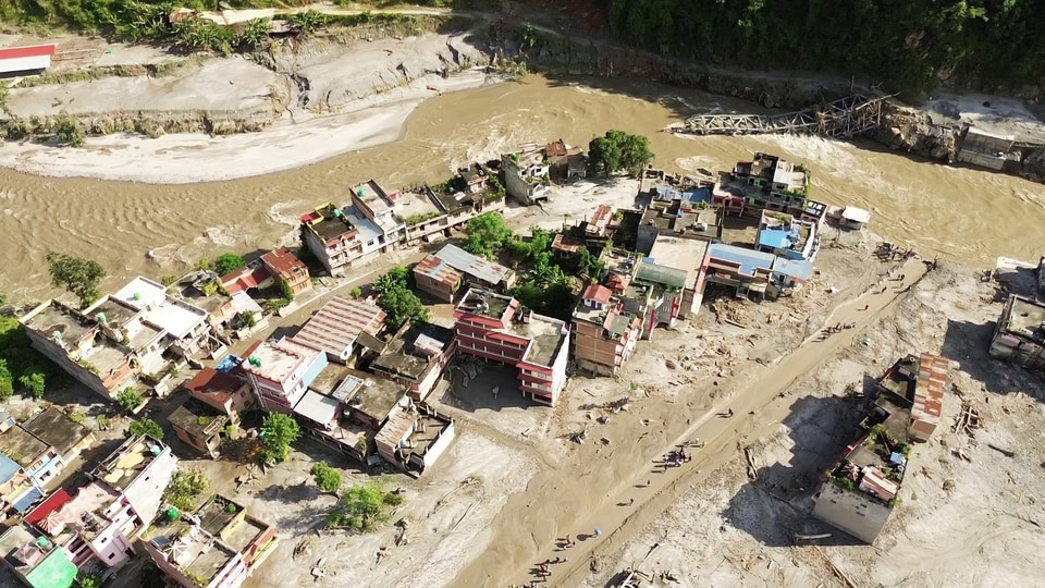
The significance of the disaster lies beyond the immediate destruction. It shows how quickly a disturbance high in the cryosphere can become a flood emergency far below. The suspected slope failure occurred in the high mountains, but its consequences travelled through a river corridor occupied by settlements, roads, bridges, hydropower facilities and border infrastructure. What began as a high-altitude geological and cryospheric event became a disaster downstream, demonstrating how difficult it is to separate an avalanche, debris flow and flood when they unfold as part of the same chain.
Nepal has seen this kind of warning before. In 1985, an ice avalanche plunged into Dig Tsho, a moraine-dammed glacial lake in the Khumbu region. The impact breached the lake and released around five million cubic metres of water into the valley below, destroying a hydropower plant, 14 bridges and about 30 houses. The scientific reconstruction of the Dig Tsho disaster showed that a disturbance at a high-altitude lake could rapidly become a destructive flood far downstream. Four decades later, the geography has changed, but the underlying lesson has not: What happens to ice and water at high elevations can determine the safety of people much lower down.
The 2021 Rishiganga disaster in Uttarakhand showed that a glacial lake does not have to burst for ice to become a flood hazard. On February 7, about 27 million cubic metres of rock and glacier ice collapsed from Ronti Peak. The mass plunged into the valley and rapidly transformed into a highly mobile debris flow that travelled through the Ronti Gad, Rishiganga and Dhauliganga valleys. More than 200 people were killed or remain missing, while two hydropower projects were severely damaged. The US Geological Survey's account of the scientific reconstruction describes how a high-altitude rock-and-ice collapse developed into a cascading downstream hazard.
The sequence appeared again in Nepal's Thame Valley in August 2024. A rock avalanche struck a glacial lake at about 4,900 metres, producing a displacement wave that breached the lake's moraine dam. The surge then affected a second lake, whose failure released more water downstream. According to the International Centre for Integrated Mountain Development (ICIMOD), the two successive breaches released an estimated 459,000 cubic metres of water and sent a debris-laden flow more than 80 kilometres downstream. Twenty-five homes were destroyed and 135 people were displaced.
South Lhonak in Sikkim in 2023 offered another version of the same emerging risk. A combination of landslide activity, glacier movement and changes within the glacial lake system produced a catastrophic flood in the Teesta basin. What makes the event particularly significant is that the vulnerability of South Lhonak Lake was not entirely unknown. A 2013 assessment had estimated a 42% probability of a glacial lake outburst flood from South Lhonak Lake. A decade later, the lake system failed and the resulting flood swept through the Teesta basin, destroying bridges and the Teesta III hydropower project. The episode raises a question that goes beyond whether the disaster could have been predicted: what happens when known mountain hazards meet expanding infrastructure and settlements downstream?
These incidents should not be treated as identical disasters. Their immediate triggers were different. Some involved glacial lake outbursts, others rock-ice avalanches or combinations of landslides, ice and water. But together they reveal a change that matters for climate policy: Himalayan hazards are increasingly capable of cascading from one process into another.
An ice avalanche can breach a lake. A landslide can block a river. A blocked river can create a temporary lake. Its failure can release water mixed with enormous quantities of sediment and rock. A glacier-related event can therefore become a flood without conventional extreme rainfall being the starting point.
Climate change matters because it is altering the conditions in which these chains develop. The 2026 ICIMOD assessment found that glaciers across the Hindu Kush Himalaya lost about 12% of their area between 1990 and 2020 and around 9% cent of their estimated ice reserves. The assessment also found that glacier ice loss has accelerated since 2000. Retreating glaciers can leave behind expanding lakes and unstable moraine systems, while warming can alter freeze-thaw processes and contribute to permafrost degradation.
The changes are not confined to glaciers. A 2026 study in National Science Review examined 8,607 landslides in the eastern Himalayan syntaxis and found a five-fold increase in annual landslide volumes above 3,000 metres between 1987 and 2020. The researchers also found evidence that landslide activity is moving towards higher elevations as glaciers retreat and permafrost melts. The mountain environment is therefore changing not only in the amount of ice it contains but also in the stability of the terrain around it.
The growing concern is what the climate crisis is doing to the physical conditions that shape these hazards. As glaciers retreat, they can leave behind expanding lakes, unstable moraine deposits and newly exposed slopes. Rising temperatures can contribute to permafrost thaw and alter freeze-thaw processes, while changes in precipitation can affect the balance between snow, ice and rain at high elevations. These changes do not automatically trigger a disaster, but they can alter the stability of the landscape and the amount of ice, water and sediment available when a hazard occurs.
This matters because the risks do not stop at the glacier. Roads, hydropower projects, bridges, tunnels, tourism facilities and settlements have expanded through narrow valleys that are also natural pathways for water and debris. Environmental assessments that focus mainly on hazards historically observed at a project site may therefore miss risks originating much higher in the same catchment. A project can appear safe under conventional flood assessments and still be vulnerable to a sudden avalanche, landslide or glacial lake outburst upstream.
The way forward is not to treat every glacier or glacial lake as an imminent disaster, nor to stop development across the Himalaya. It is to make development decisions based on the risks of a changing mountain system. High-altitude glacier and lake monitoring needs to be connected with satellite observations, seismic instruments, weather stations and downstream river gauges. Early-warning systems should be capable of detecting disturbances in upper catchments and communicating their potential consequences to communities below. Environmental assessments should also consider how different hazards interact across an entire river basin rather than examining each hazard in isolation.
The Nepal disaster brings this challenge into sharp focus. The event began high in the mountains but its consequences travelled far downstream through a densely used river corridor. As the Himalayan cryosphere changes, disaster preparedness will increasingly depend on understanding not only the river but the glaciers, lakes, slopes and frozen ground that shape what reaches it.
(The views expressed are personal)
This article is authored by Ritu Kumari, development professional, Bengaluru.


