
 E-Paper



Cyclone Arnab: Why Bay of Bengal storms tend to form after the monsoon
Months of monsoon leave the Sea warm, and a layer of river water allows heat retention even under a storm. The science behind the post-monsoon cyclone season.

 Prefer HTon Google


Cyclone Arnab, expected to cross the Andhra Pradesh coast on Wednesday morning, comes from the Bay of Bengal, which produces four cyclones for every one in the Arabian Sea and records most such storms post-monsoon.
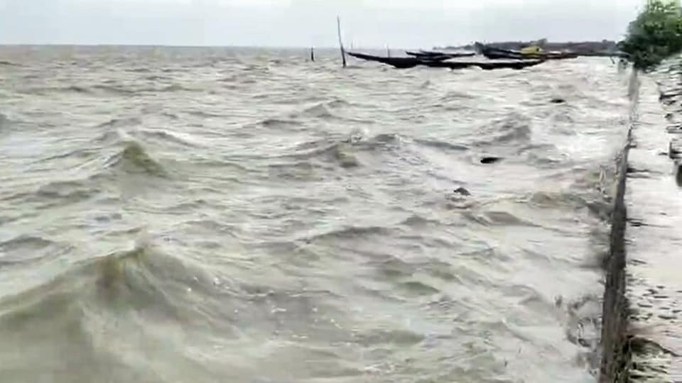
The Bay of Bengal is warmer than the Arabian Sea, and it also receives the remnants of Pacific typhoons. After the monsoon, a deep layer of warm water and a less salty top layer keep the Bay’s surface warm even beneath a storm.
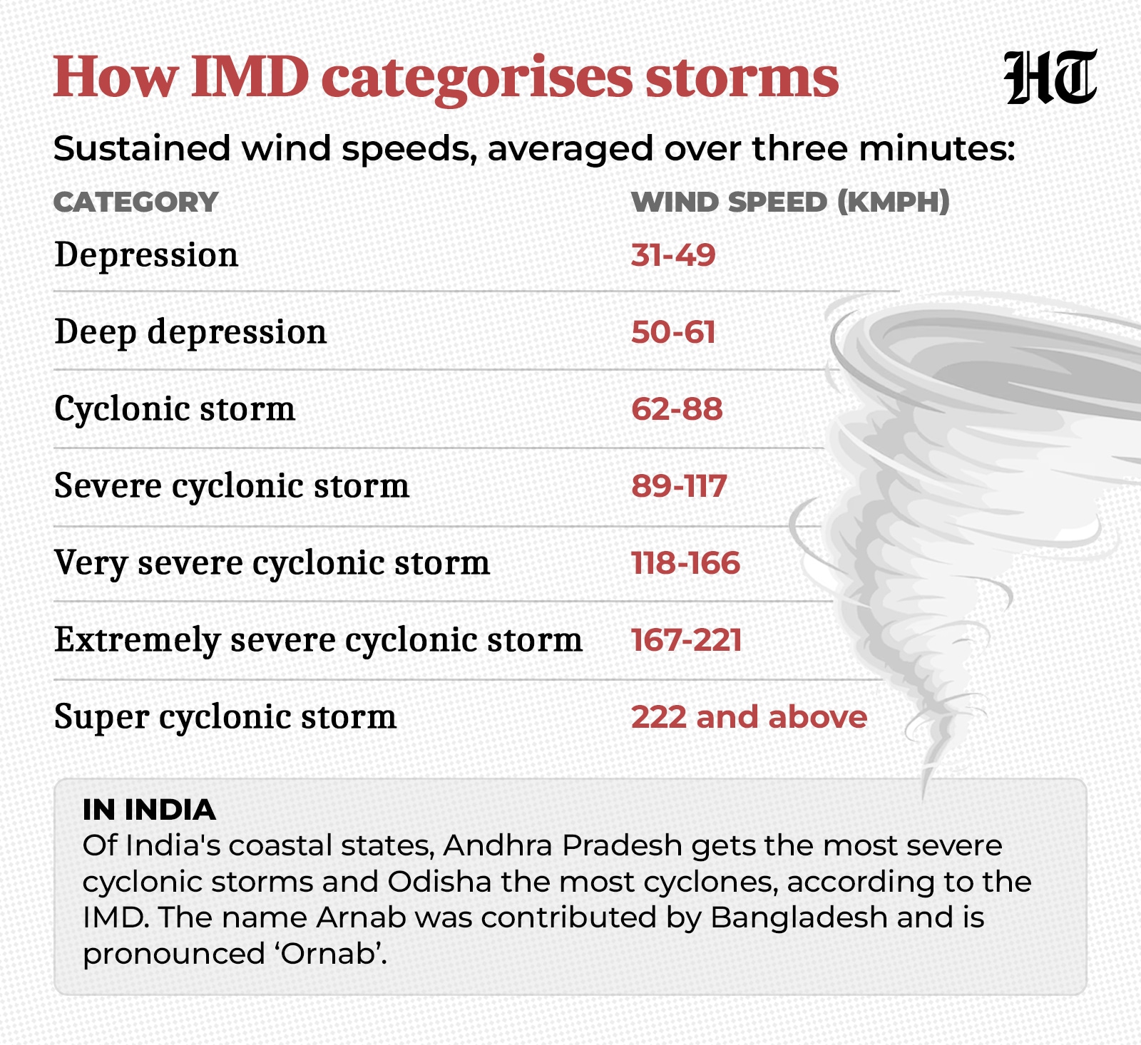
The India Meteorological Department (IMD) expects Arnab to cross near Puducherry’s Yanam, between Bapatla and Visakhapatnam in Andhra Pradesh, before noon on Wednesday as a very severe cyclonic storm, the third-highest of its five cyclone categories.
At 2.30am on Tuesday, the storm was over the west-central Bay, moving west-northwest at 25 kmph with sustained winds of 125-135 kmph, gusting to 150 kmph. Andhra Pradesh, Odisha and West Bengal are among the six states and Union territories preparing for the storm.
How a cyclone is formed
A cyclone is a giant spinning storm that forms over warm seas. The IMD considers one to be a cyclone once its sustained winds reach about 62 kmph.
Every cyclone begins as what meteorologists call a disturbance, a patch of sea where the air pressure has dipped a little below that of the surrounding air. Winds flow in towards the patch, and the Earth’s rotation bends them so they start to circle it. The IMD says a cyclone cannot form without such a starting point.
The patch then needs warm water beneath it, at least 26.5°C to a depth of at least about 50 metres. Air above the sea warms, picks up moisture and rises. Higher up, the moisture condenses into cloud and rain and releases heat, which lowers the pressure further and draws in more air. The air about 5 km up must also be moist, or the clouds stop swelling.
Meteorologists call the difference between winds near the surface and winds higher up vertical wind shear. A growing storm is a tall tower of thunderclouds. If the winds near its top blow much faster than those near its base, or in a different direction, they pull the tower apart and the swirling storm breaks up. The IMD treats shear of less than about 36 kmph as low enough for a cyclone to form.
Even when all these conditions are met, the IMD notes, many disturbances never become cyclones.
Also read: As Cyclone Arnab approaches, a look at the science behind naming of cyclones
Four to one
The Bay of Bengal gets four cyclones for every one in the Arabian Sea, according to the IMD. Between them, the two seas average about five a year.
The Bay draws storms from two sources.
Some form within it, over its southeast and the adjoining Andaman Sea. A common starting point is an easterly wave, a weak ripple in air pressure that drifts westward across the tropics every three or four days. A patch of low pressure can form in the dip of the wave. The IMD describes these waves as the “seedling” for a large share of cyclones. Whether the seedling grows depends on the warm water, moist air and calm upper winds it meets.
Others begin far to the east, as typhoons, the name used in the Pacific for strong tropical cyclones. The northwest Pacific produces about a third of the world’s tropical cyclones. Some typhoons move west across the South China Sea and over mainland Southeast Asia. Over land, a storm loses the warm water and moisture that feed it, and it weakens. What survives the crossing is a weaker spinning patch of low pressure, which can grow into a cyclone again over the warm Bay.
On the other side of the Indian peninsula, the Arabian Sea has fewer sources for cyclones to form. Apart from storms that form locally there, it gets only the Bay storms that survive the crossing over southern India, and most of those weaken once they reach land. The Arabian Sea is also cooler than the Bay, which, in the IMD’s words, “inhibits the formation and intensification of the system”.
Why October and November
Cyclones in the north Indian Ocean are most frequent in November, with a smaller spike in May, according to the IMD. Arnab became a cyclone on Monday, early in the post-monsoon season, which runs from October to December.
Few cyclones form during the monsoon. Its strong westerly winds blow in the lower atmosphere while very strong easterlies blow higher up, and this shear stops cyclones from forming. The weaker systems (depressions) that still form usually reach the Odisha-West Bengal coast within a day or two, too soon to develop into cyclones.
The monsoon also keeps the Bay of Bengal warmer than the Arabian Sea. Over the Arabian Sea, stronger monsoon winds churn the waters and push surface heat deeper. Over the Bay of Bengal, the monsoon winds are weaker. Rain and rivers also spread a layer of less salty water across the top of the Bay, and the weak winds cannot mix it with the saltier water below. So the Bay holds on to its heat and stays warmer than 28°C through the monsoon, oceanographers SSC Shenoi, D Shankar and SR Shetye found in a 2002 study published in the Journal of Geophysical Research.
That warm water is still in place when the monsoon retreats.
After the monsoon, the Bay of Bengal also stays warm while a storm passes over it. A cyclone usually cools the sea along its path, as its winds churn the water and pull colder water up from below. Warm water is a cyclone’s fuel, so this cooling works against the storm.
In the Bay of Bengal, though, the cooling is about three times weaker after the monsoon than before it, S Neetu and colleagues found in a 2012 study based on a computer model of the ocean, also published in the Journal of Geophysical Research.
They found two reasons. After the monsoon, the warm water reaches deeper, so a storm’s churning brings up more warm water instead of cold. And the less salty top layer, at its freshest after the monsoon’s rain and river runoff, resists mixing with the water below. Because of this, the surface stays warm under the storm.
Satellite data from the north Bay of Bengal show this effect. “Even the strongest post-monsoon cyclones do not cool the open north Bay of Bengal,” Debasis Sengupta and colleagues at the Indian Institute of Science (IISc), Bengaluru, wrote in a 2008 study published in Atmospheric Science Letters.
What is changing
The gap between the Bay of Bengal and the Arabian Sea has narrowed in recent decades. Researchers at the Indian Institute of Tropical Meteorology (IITM)-Pune, comparing data between 2001-2019 and 1982-2000, found that the number of cyclones in the Arabian Sea rose by 52%, while the number in the Bay of Bengal fell by 8%. The study, published in the journal Climate Dynamics in 2021, linked this increase in the number of cyclones in the Arabian Sea mainly to warmer sea surface temperatures.
Even so, the Bay of Bengal recorded more cyclones in the recent period, 62 against the Arabian Sea’s 38. Its warmer waters and its share of storms from the Pacific keep it ahead, with Arnab the latest to form there.


