
 E-Paper



Malik Ambar’s 400-year-old water system holds lessons for drought-hit Marathwada
Construction of this system began around 1610 and was largely completed by 1615 and carried water from the Sawangi hills through underground channels

 Prefer HTon Google


Four centuries after Malik Ambar – who rose from slavery to become an administrator and military leader of the Ahmednagar sultanate in the early 17th century – developed an innovative water supply system for Khadki and the settlement that later became Aurangabad and is now known as Chhatrapati Sambhajinagar, his engineering legacy continues to hold lessons for drought-hit Marathwada where villages continue to face drinking water shortages and depend on tankers during periods of scarcity.
Even as the region commemorates the 400th death anniversary of Malik Ambar in 2026, the water management system developed by him serves as a reminder that long-term water security depends not only on rainfall but also on how effectively available water resources are identified, conserved and distributed.
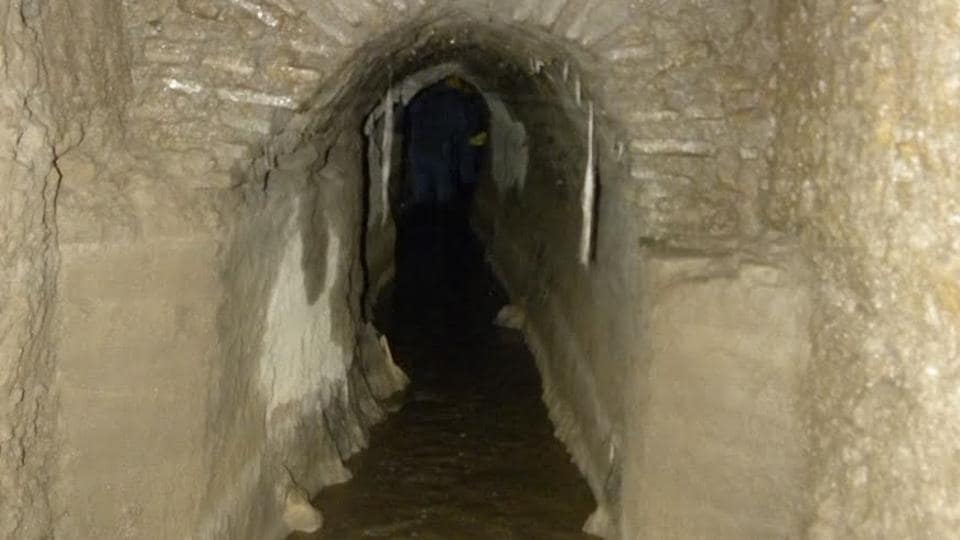
One of his most significant contributions was the Nahar-e-Ambari, a water channel designed to bring water from the surrounding hills to the growing settlement which relied on the natural slope of the terrain to transport water through underground channels and earthen pipes, reducing the need for mechanical pumping. The underlying principle of this system was to identify dependable water sources, understand the natural contours of the land, and use gravity to carry water to where it was needed. It demonstrated how local geography can be harnessed to meet the needs of a growing population while making efficient use of available water resources.
According to historian Sanket Kulkarni, who has served as a non-governmental member of the Maharashtra government’s fort conservation committee, construction of this system began around 1610 and was largely completed by 1615. It carried water from the Sawangi hills through underground channels before distributing it across the settlement through earthen pipes. The network supplied important locations, including the Naukhanda Palace, Gulshan Mahal, Shahgunj and parts of the old market. Its underground channels extended across several kilometres, with their dimensions varying according to the requirements of different areas.
“When Malik Ambar shifted his capital here to Khadki, his first (priority) was to manage water for the city. He initially scanned the entire region and found out natural water streams and by using underground channels, he supplied water across the city through earthen pipes. The entire underground water channels’ system spanned four to five kilometres. It has different width and length depending upon the area,” Sanket Kulkarni said.
Ajay Kulkarni, an architect and designer who is also the convener of the Indian National Trust for Art and Cultural Heritage (INTACH), Aurangabad, said that the system made effective use of the area’s natural topography and geology. “This system used the natural slope of the hills to move water through stone or clay pipes and underground channels. Due to hard rock, the rate of loss of water through percolation is very less which was efficiently used by Ambar,” Ajay Kulkarni said.
While much of the original network has disappeared over the centuries due to neglect and urban expansion, remnants of some structures can still be seen in the old city, offering glimpses of an infrastructure system designed to serve an expanding settlement long before the advent of modern water supply engineering.
Speaking of Marathwada’s recurring water crisis wherein the number of water tankers operating across the region reportedly crossed 200 in June 2026 with Chhatrapati Sambhajinagar district accounting for the largest share, Malik Ambar’s system offers lessons in planning around local conditions rather than relying exclusively on large infrastructure projects. Identifying natural drainage patterns, protecting traditional water sources, harvesting rainwater and improving groundwater recharge could help supplement modern water supply networks, particularly in areas vulnerable to seasonal shortages. Maintaining the existing infrastructure is equally important wherein mapping surviving structures and assessing their potential for conservation can help preserve an important part of the region’s engineering heritage.
While Malik Ambar’s 400-year-old system cannot independently meet the demands of today’s cities and their vastly larger populations, its emphasis on understanding the landscape, using gravity efficiently and planning for the distribution of limited resources remains relevant as Marathwada grapples with recurring droughts.


